
Last updated - October 2024

Cascade River State Park
If you enjoy my blog, please consider signing up below for email notifications of my latest posts I will not share your email.

Classic Minnesota Northwoods Waterfall Hike
Cascade River State Park is the scenery that I see when I close my eyes and think of the North Shore. It has large, small, and cascading waterfalls throughout the first mile of hiking - there are so many waterfalls that it’s impossible to count them all. The pine trees are tall and old, and their roots and needles cover the trails. Much of the river cuts out a gorge, but it’s a wider than Temperance River, and as a result, there are multiple places that you can access the river, being able to touch it or walk out into it. Typically there are less people here than some of the other North Shore State Parks, simply due to the longer drive north to get here. The trails are not difficult, but are still wild and rugged. It shouldn’t take long to feel relaxed here.
The other special aspect of Cascade River Sate Park is its shoreline. This is the one MN State Park that has an accessible shoreline that allows you to walk along the water’s edge of Lake Superior for a mile and a half (one-way) and enjoy the relaxing sound of the waves.

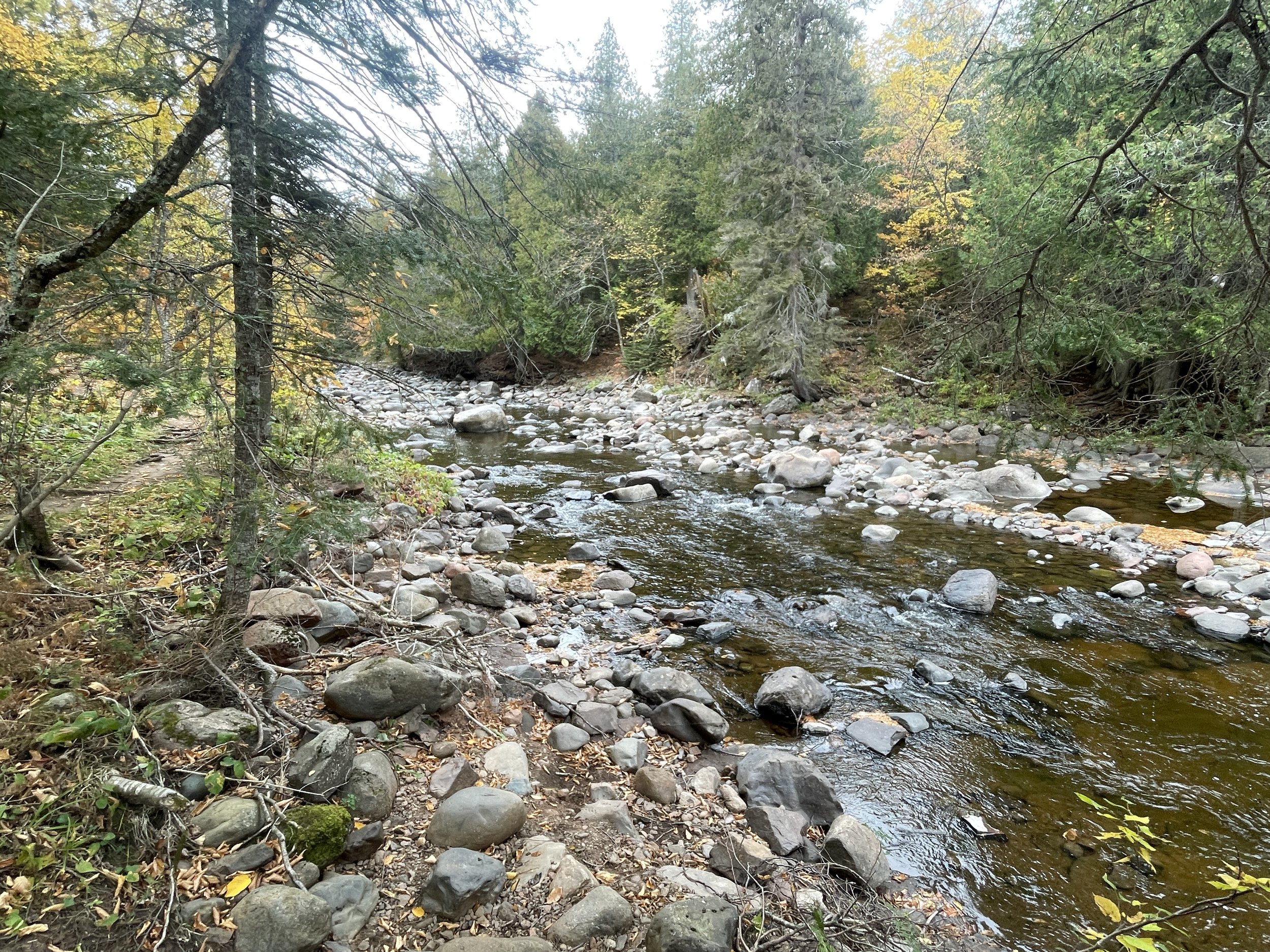
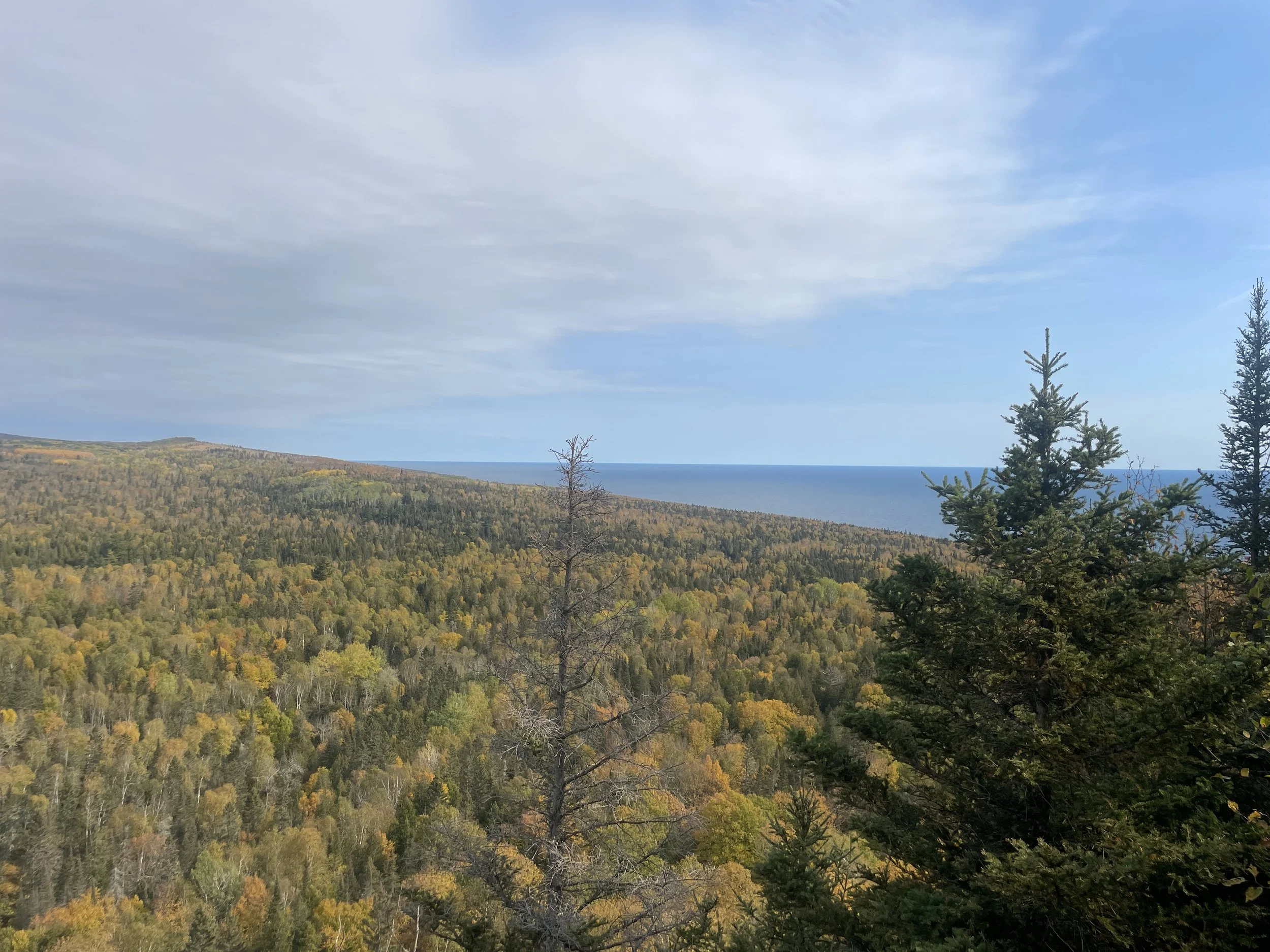
Cascade River State Park - viewed from the hiking bridge crossing Cascade River
Location and Parking
Cascade River is the fifth Minnesota State Park as you drive north on MN-61 from Duluth (following Gooseberry, Split Rock Lighthouse, Tettegouche, and Temperance River). Without traffic, Cascade River is close to a 2 hour drive from Duluth. Judge Magney is the next park, north of Cascade by about a half hour.
There are four places to park in Cascade River State Park. The first is right off of MN-61 just south of the bridge that crosses over Cascade River. This is on the west side of the highway, and I would consider this the main trailhead parking. The second parking area is north of the bridge on the lake-side of the highway. And the third spot is a parking lot near the campground. If you park in the campground, make sure to hike the full waterfall loop down to the highway and back on the other side. Some waterfalls are only visible on one side of the trail. The last place to park is on the other side of the River Trail next to Hidden Falls, at the Superior Hiking Trail Cook Country 45 Trailhead.
This post stands on its own, but it is a part of a larger network of posts I’ve written regarding things to do along Minnesota’s North Shore. This is a link to my full North Shore Guide for anyone interested. It’s an external link so you won’t lose your spot. I will also re-post this link at the end of this blogpost.

Trail Marker along MN-61 describing the waterfall loop hike
Lodging Options
Cascade River State Park has a campground with showers. If Gooseberry, Split Rock, and Tettegouche campgrounds are full, check Cascade River. You’ll have a better chance here simply because it’s a further drive north than the other parks.

When kids are little, consider getting a couple of sites together and bring grandparents, aunts and uncles, or friends to help out.
Cascade River was the first place we went camping as new parents. People ask me when is the best age to start taking kids camping, and then they’ll give me an age - my kids are 8, do you think they can do it? Our son was 9 months. Of course your kids can do it. Just don’t make your kids go to bed before you do - being in a tent by yourself might feel a little scary.
A camping life hack with young children - book two campsites together and have grandparents go with. Two extra adults to share the cooking and cleaning, or hold a baby while you set up the tent makes camping with babies or young kids a lot easier. Once kids are old enough to follow directions, give them some jobs to do - finding sticks for a fire, setting up their sleeping bag, helping unload the car, making snacks, helping cook supper, etc. This will make your life a little easier, and they won’t be bored while they wait for you to get everything ready. Camping is a team sport!
Campsites and campgrounds are fun for kids to explore too. Walk around the site and surrounding areas together and mark off boundaries, then let them play in the space that you’ve defined. They can feel a little more independent, and giving them a little more space gives you some more space.
If a hotel would be better option, Tofte, Lutsen, and Grand Marais are good, nearby options to search.

This Chicco Caddy Hook-on Chair was one of my favorite baby shower gifts. We used this camping and during picnics when we went hiking. Amazon still has them for sale.
Hiking at Cascade River State Park
My recommendations for hiking at Cascade River would be to hike up the Cascade River from MN-61 along the Waterfall Trail Loop and take every spur trail down to the river (orange trail). Continue hiking another mile past the bridge on the west side of Cascade River following the pink trail, down the 96 steps to the river and find two more waterfalls. Take your shoes off and enjoy the Cascade River above the falls area if the river level is low and the water is calm.
On your way back to the parking lot, south of the bridge, walk on the other side of the Cascade River to see the full waterfall loop.
When you get back to the highway, cross over the highway on the east side of the river, and walk down the steps to the Lake Superior shoreline.
Walk along lakeshore rocks (blue trail) for as much time as you have remaining. Return the same way.
Before leaving the park, drive to the Cook County 45 Trailhead for the Superior Hiking Trail (10 minute drive from the main parking areas in Cascade River - Turn on Co Rd 7 from MN-61 and go 2.4 miles, and then turn left onto Pike Lake Road for 2.6 miles). Park at the trailhead and cross under the bridge to find Hidden Falls.

Waterfall Trail (orange) - This 0.5-mile loop hike is relatively easy, with an elevation gain of 125ft, and travels past most of the waterfalls in the park.
Cascade River Loop (pink) - Keep going up the Cascade River for an additional 2 miles out-and-back (on the west side of the river to see two additional waterfalls, or hike the full 7-mile loop (with an additional elevation gain of 1,200ft).
Hidden Falls (pink) - There is another place to park closer to Hidden Falls for those preferring not to hike the full 7-mile loop on the River Hike. This is a 0.8-mile out-and-back hike from the Superior Hike Trail parking lot, and has a negligible change in elevation.
Lookout Mountain (green) - Add 1.7 miles out-and-back for the shortest option to get up to Lookout Mountain and back / Hiking Club Trail (orange, green, and purples) - To hike the entire Hiking Club Trail, the loop trail is 3.2 miles
Lake Superior Shoreline Trail (blue) - Enjoy up to 3 miles out-and back along the shoreline rocks. A second option is to make this a loop hike and come back along the red trail. This options adds a third of a mile.
Cascade River Waterfall Lower Loop
Distance / Elevation Gain - This is a relatively easy 0.5-mile loop hike with an elevation gain of 125ft. This trail is marked in orange and goes past most of the park’s waterfalls.

I’ve marked the waterfalls with pins. Several of these pins represent cascading waterfalls, making it difficult to get a true count of the number of waterfalls. Some waterfalls are visible on different sides of the trail, so walk the full loop to see everything, and take the spur trail south of the bridge on the west side of the river and scramble along the riverbank.
I typically park in the small lot right off of MN-61, so that’s where I’ll start this trail review. From this parking area, it might not be immediately obvious where to start. Walk a few steps north, and then keep going on the left side of the highway barrier. Just after the barrier, the trail veers off to the left, down to the Cascade River.
I don’t know why, but I typically hike loops counter-clockwise, so that’s the order I’ll share my pictures in. I’ve been to this park multiple times, in each of the seasons. I keep returning because waterfalls change a lot by season and year. I’ll indicate which views are the same, even though they may look quite different.

The trail starts following the left side of the highway and eventually makes a hard left down to the river.

Cascade River - start walking upstream on the east-side of the river
This is not a hard trail, but the trail surface is a combination of steps, bridges, and hard-packed dirt with a lot of tree roots that require some attention to prevent tripping over them.

Bridge over a smaller creek feeding into the Cascade River
The first view of the first waterfall is going to be a bit of an awkward angle. Don’t worry, after some steps, there’s a better view ahead.

First view of the waterfall along Cascade River walking upstream on the east-side

Keep going up the steps, and the trail will lead to a better head-on view of the waterfall.

A close-up of the same waterfall in January 2023. Frozen waterfalls are wicked awesome. You can see the water flowing under that one open spot. And you can very much still here the waterfall from the trail. It’s not even close to frozen solid.

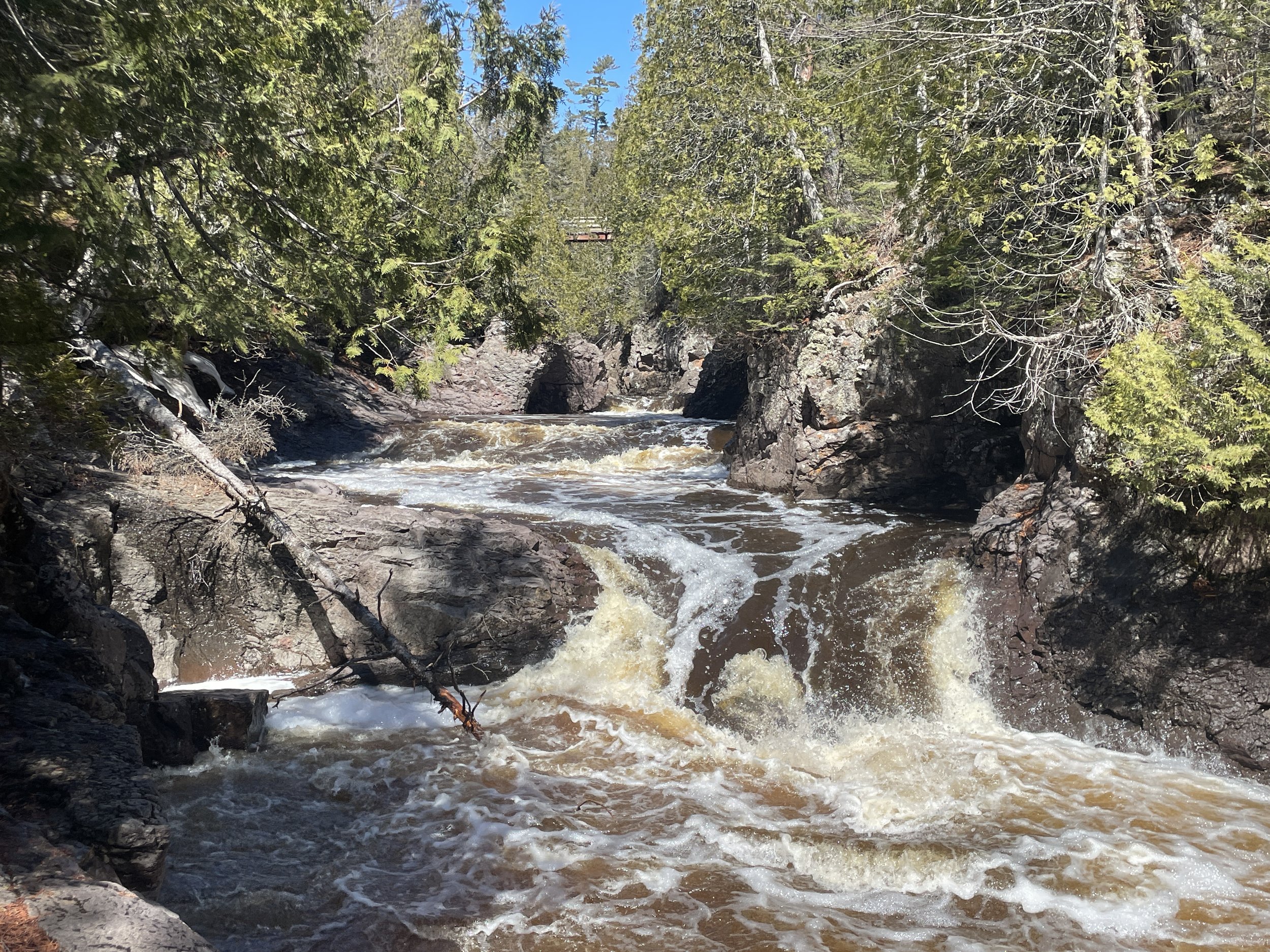
Same waterfall as above, raging with the melted snow. This picture was taken in April 2024. If this waterfall has a name, I’m not sure what it is.
Shortly above this waterfall, the trail from the campground joins. If you are heading upstream or to Lookout Mountain from the campground, don’t forget to circle back downstream to the MN-61 bridge, or you will miss several waterfalls.

My little hiker leading the way with his map

Just over the steps, the trail crosses over the Cascade River, and the Cascades will be just upstream with a nice view.
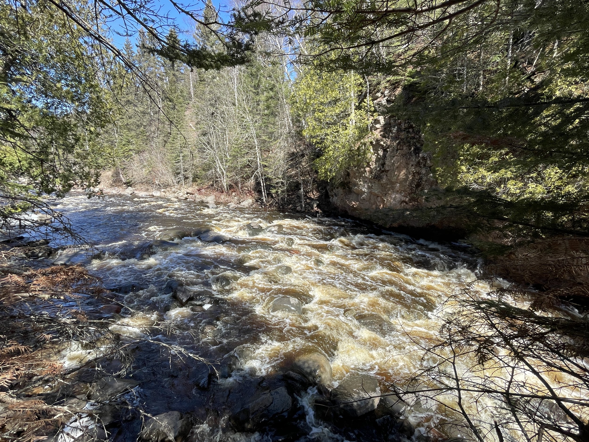
At this point in the trail, there is a bridge that crosses over the Cascade River. You can keep hiking upstream on the east-side if you are going to hike the Cascade River Trail (and in 7 miles it will make a loop that ends on the other side of the bridge). Otherwise, plan to cross the bridge here - and even if you hike the River Loop, walk across this bridge and then return. The iconic Cascade waterfalls are visible from this bridge and a viewing platform just below it on the river’s west side.

July 2007 - This waterfall has a name - The Cascades. This is visible from the bridge. Keep walking a few steps to the west over the bridge and there is a platform where you can see the waterfalls that cascade into it from upstream.

Same view as above from the bridge after snow melt in April 2024

This picture is from the same platform in July 2009

July 2007 - This is the last waterfall visible in the Cascade section from the pictures above.

Hiking with my boys in August 2015. We also camped here that year.

Same waterfall - Oct 2024 after a pretty dry summer and fall

The Cascades decked out in it's winter beauty- this was from January 2024.
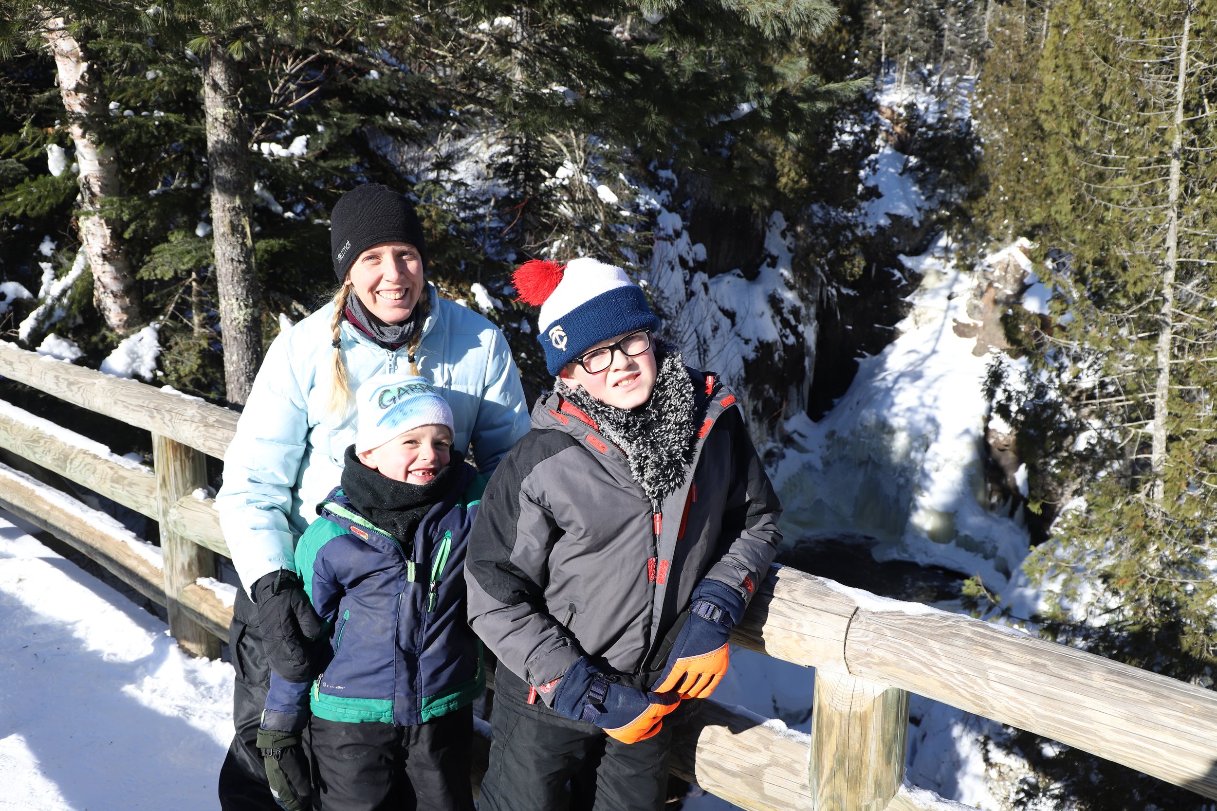
And a family picture in front of the same falls in January 2019
We’ve established that I love this park and this particular set of cascading waterfalls? These are just my favorite pictures - we come here frequently. It is cool to see though how much it changes based on what water level is present.

Standing on the same bridge looking downstream, you can tell there are more waterfalls. These can be seen shortly on the trail along the west-side of the river.

Same picture as above in the winter looking downstream - Jan 2019
You may decide to keep hiking upstream - there are three more waterfalls in the park along the Cascade River Trail. Two of them are within one-mile from the bridge. For more information on that hike, keep reading below. When you choose to return to your car, head back along the west-side of the river. For the moment, I’m going to close out the return part of the Cascade River Waterfall Lower Loop.

Hiking back down along the west-side of the Cascade River
One of my favorite parts of this park are the distinctive wooden staircases that line both sides of the Cascade River.
In a short distance, there will be a way to walk out onto the rocks. These small rapids are visible looking upstream, and the bridge is just barely visible in the background. When the water is low, there is an option to scramble along the rocks upstream all the way to the bridge.
April 2024 - Looking upstream back towards the bridge

Oct 2024 - much lower water levels

Oct 2024 - First trip I realized I might be rock scrambling past my age, at least with a hiking bag on - it takes some effort, but it is possible to get to the bridge when the water levels are low enough
Rock scramble back towards the trail, and this is the view from on top of the next waterfall.

Standing in the same spot as the above picture, you can see the next large waterfall. (April 2024)

April 2024 - Stay out on the rock edge and walk a bit more downstream to see the water as it tumbles over the next fall

Looking further downstream, you can see the river tumble again. (April 2024)
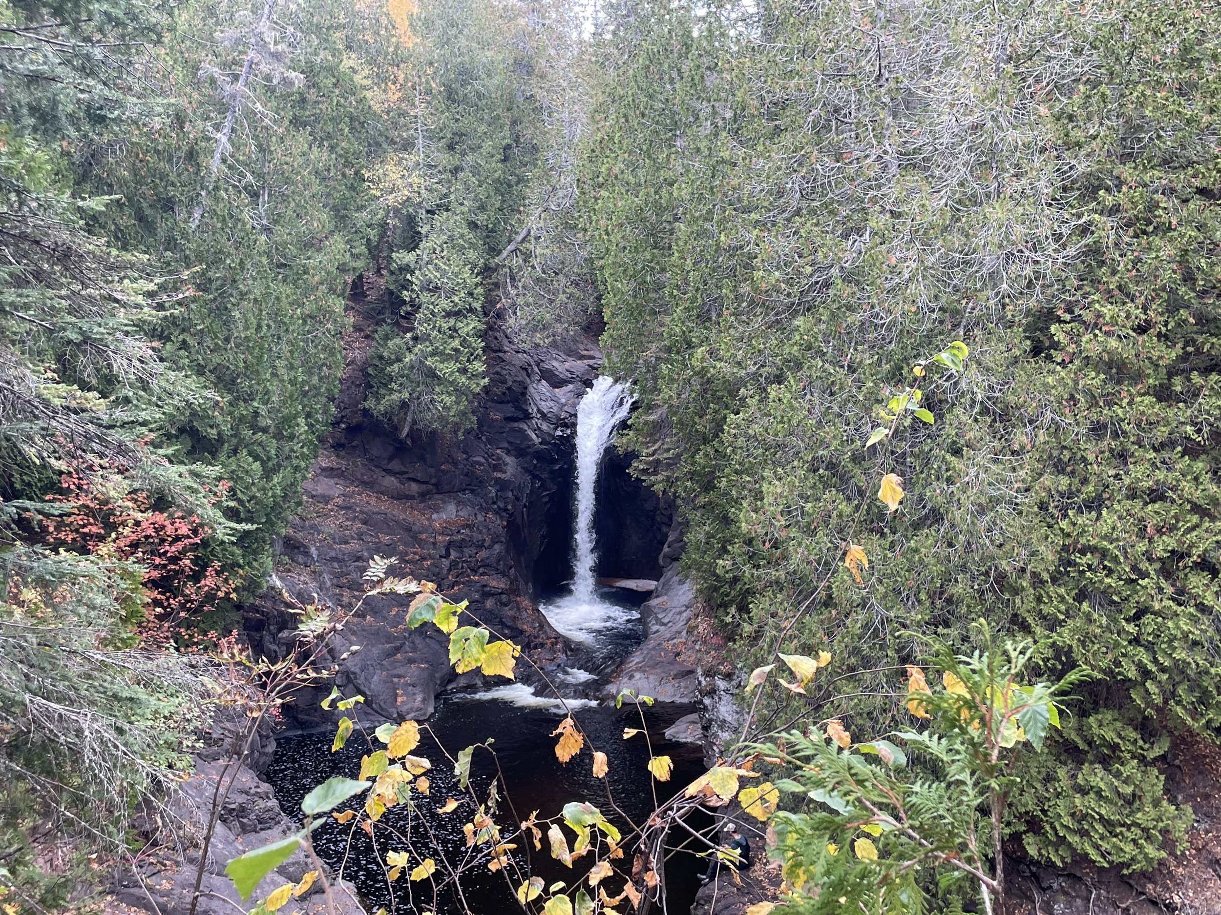
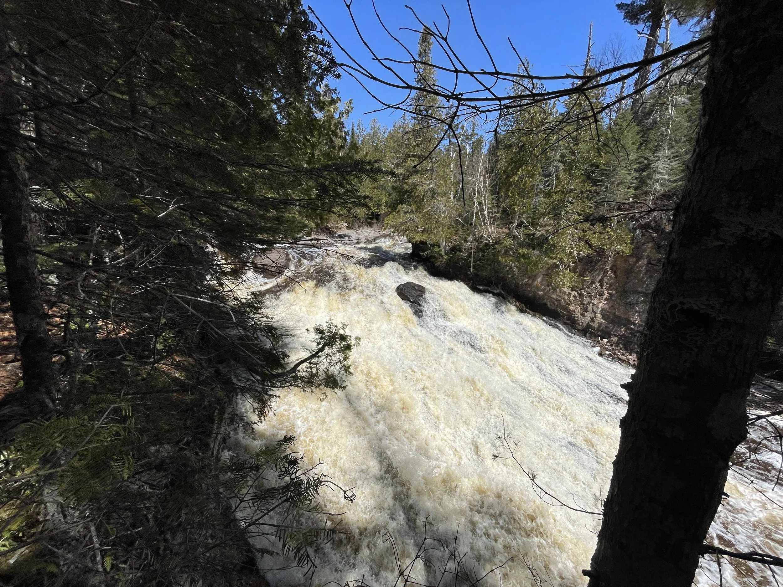
The last waterfall is my favorite. This waterfall is called Cascade Falls - don’t get me started on the lack of creativity in waterfall names in Minnesota… This one is only visible from the west-side of the Cascade River, and it’s towards the end of the trail

Cascade Falls (July 2007)
Cascade Falls (Oct 2024)

Cascade Falls (April 2024) - This waterfall looks so different than previous times I’ve seen it, I thought for a moment it was a different waterfall. I would highly recommend hiking the falls trails in more than one season.
The trail ends with a pretty view of Lake Superior under the MN-61 bridge as the Cascade River flows out and joins it.

The Cascade River flows into Lake Superior, framed by the MN-61 bridge

Oct 2024 - a particularly blustery fall day had the waves on Lake Superior quite high
Cascade River Trail
Distance / Elevation Gain - There are a few more waterfalls along the Cascade River, upstream from The Cascades and the hiking bridge. For a longer hike, add on two miles to the Lower Cascade River Waterfall Loop, and head upstream along the west-side. There are two waterfalls. The first is about 0.7 miles from the bridge, and this is a small step waterfall. The second is approximately 0.3 miles further upstream and this is a larger and wider waterfall with more of a gradual slope than a free fall. This trail adds about 200ft in elevation gain.
There is also an option to hike the river as a 7-mile loop, with close to 1000ft in elevation gain. This is one of the longer loop hikes along the North Shore. The trail crosses the river on the Pike’s Lake Road bridge, and heads back along the other side of the river. The entire Cascade River Trail is marked in pink below. Waterfall locations are marked with pins. Parking is marked with black stars.

Map of the full 7-mile Cascade River Trail loop is in pink
There is one more waterfall (Hidden Falls) that is close to Pike’s Lake Road. To get to Hidden Falls without hiking the entire 7-mile River Loop, keep reading (or click here to skip to the Hidden Falls section).
Follow the steps to the river
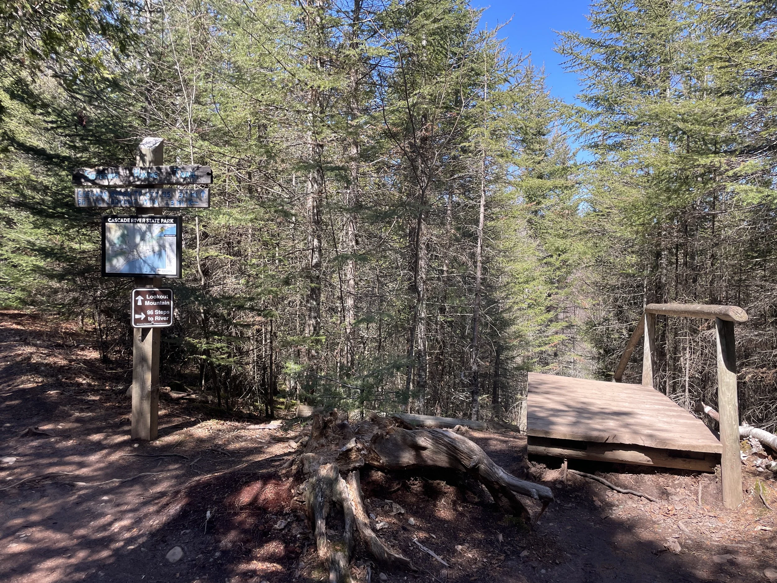
After crossing the bridge to the west side of Cascade River, stay on the trails to the right which remain closer to the river when walking upstream. There are a couple of intersecting trails that lead off to Lookout Mountain.
Shortly there will be a sign for “96 Steps to River” - take those steps. 96 steps aren’t terrible to climb back up. This is a moderately easy hike for the next mile, and doable for younger kids. Beyond that mile, there is a lot of up-down-up-down totaling almost 1000ft in elevation gain, and the trail is a seven-mile loop. I’d rank the total River Loop trail is moderately challenging. It’s a quiet hike - I saw 3 people on one of the peak fall color weekends in October. For the right person, this entire loop trail is amazing. For kids, hike out-and-back to the two falls I’ve mentioned and let them play in the river if the water is low enough. Then drive out to Hidden Falls.

I love the characteristic wooden steps and rails of Cascade River. The 96 Steps are similarly designed as along the Lower Waterfall Loop.
At the bottom of the steps, the trail heads right back out to the river, and the next mile the trail will hug shoreline pretty closely. At this point in the Cascade River, the river is wide and typically shallow in the later summer months and into fall. Try fishing, be daring and see if you can make it across the rocks without falling in, or just take your shoes off and walk in the river for a ways. In the spring or after a storm, obviously, stay out of the river.

(Aug 2015) Hiking isn’t just about walking - the moments you stop and play are the reason to hike. This was a fun spot for the kids to hop on the rocks in the Cascade River. They were almost able to make it the full way across.

(Aug 2015) And the dads stopped to fish while the kids played

(Aug 2015) The rest of us chilling on the rocks of the riverbank

(Aug 2015) Trying another spot for fishing - The trail is visible in this picture, right next to the riverbank.
(Oct 2024) Similar section of the Cascade River as above. This is as dry as I've seen the river before.
The Cascade River in April 2024 was unlike I’d ever seen it before. Again, a huge recommendation for April hiking!
In April 2024, I ventured up to the two waterfalls. The Cascade River was roaring in a way I’d never seen it before. Seeing the waterfalls after snowmelt was something else.

(April 2024) Cascade River in approximately the same spot as where we were playing in the river in the summer months
To find the waterfalls, hike about 0.7 miles from the bridge (down 90 steps and follow the River Trail). Compared to the lower falls, this one is pretty small. There isn’t a great spot to see this one from the trail. You’ll need to navigate out a bit on the riverbank rocks for a picture.

First waterfall upstream of the bridge - August 2015

Same waterfall in April 2024

(Oct 2024) Same spot in the river - a small waterfall is still present
Keep wandering upriver a little further, about a third of a mile. Most likely you will have this trail to yourself. The trail will stay next to the riverbank. The sound of rushing water is soothing, especially in the silence of the rest of the forest.

Upstream a short distance from the falls

(Oct 2024) Most of these rocks were underwater in the above picture
The second waterfall doesn’t tumble straight down, and the river doesn’t really narrow either. This picture doesn’t do it justice. At the top of these falls are some rocks to sit on that look like a good spot for a picnic.
(April 2024) Second waterfall upstream of the bridge

(April 2024) At the top of the second waterfall
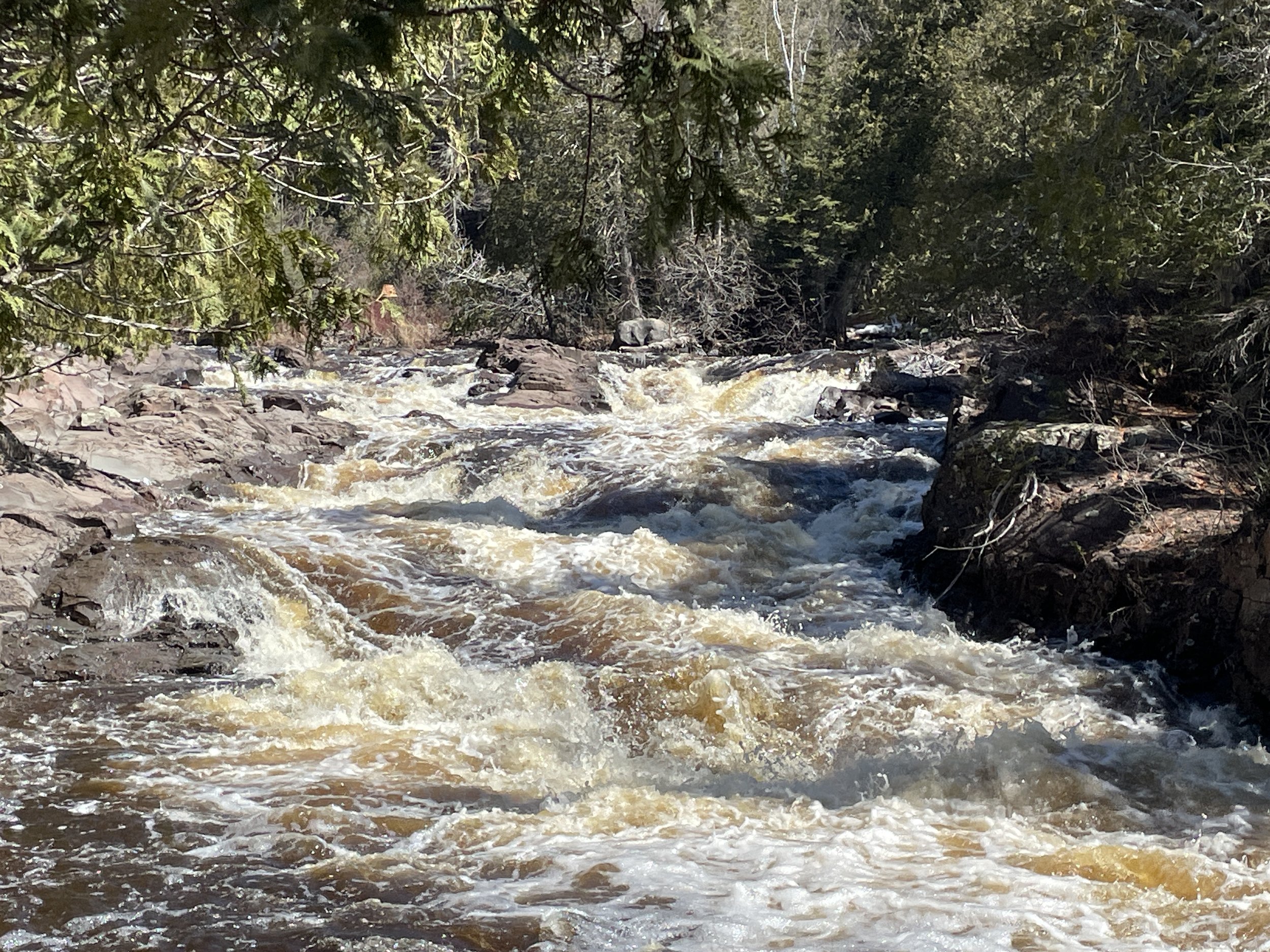
(April 2024) There are some smaller rapids just above the waterfall

(April 2024) Looking back downstream over the falls
After the second waterfall, the trail moves to the left of the Cascade River and the up and downs begin. Most of the trail is covered in pine trees and birch trees. Follow the Superior Hiking Trail signs.
Note that there is one Superior Hiking Trail campsite (Big White Pine) about the time the River Trail splits off and heads into the woods. There is a similar looking trail to Big White Pine. The trail will come to a dead-end in the campsite. Just turn around and head back to re-catch the SHT trail.

There are a few points where the trail gets further into the woods. I do love this park with its tall trees, pine needle and root-covered trails, and moss growing on the rocks and the sides of trees. And green is such a lovely color after winter.
I’ve ventured the entire Cascade River Loop Trail once, in October 2024. Pretty much from where the trail leaves the Cascade riverbank until Hidden Falls, it looks like this. A dirt trail, lots of trees and no other hikers. It’s a beautiful forest.

(Oct 2024) Hiking the full Cascade River Loop Trail

(Oct 2024) This part of the trail is also part of the Superior Hiking Trail, which is maintained with amazing engineering over every water obstacle. This bridge went over a small creek.

(Oct 2024) Fall is my favorite time to hike. No bugs, no humidity, amazing colors!
About halfway down the first side of this loop trail I’ll admit I started to get a little nervous. I hadn’t seen another hiker in over an hour. I was on a long loop trail, not an out-and-back, which meant if there was a problem with a section of the trail that wasn’t marked, I could have ended up in the woods past nightfall. I always hike with a headlamp, but haven’t had to actually use it yet. There weren’t any trail problems, and it’s all marked quite well. Additionally, I hike with GAIA, which tracks where I am, even in airplane mode, as long as I have pre-downloaded the maps. But even still, it was weirdly quiet on this trail without the presence of other hikers (I saw three the entire loop).
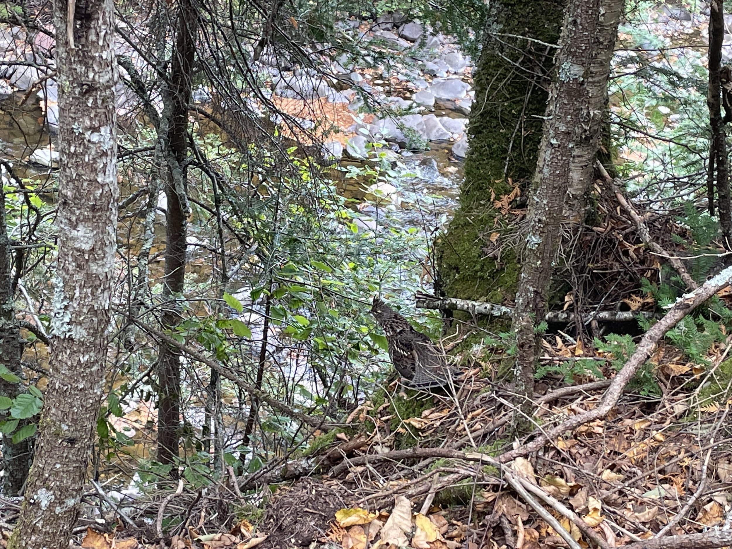
(Oct 2024) Roughed Grouse along the Cascade River Loop Trail
Every once in awhile, a story about an animal creeps into one of my blogposts, and this time the above grouse gets a shout out. So I’m on this 7-mile loop trail, essentially alone (minus those three other hikers), and pretty early into the hike I stop and take a picture of this bird. I took this picture with my phone, so you can see how close I was able to get. I leave it alone and keep walking. 10 or so minutes later, I see it again. And another half hour again. And by the time I’m past Hidden Falls and on my return side of the loop, I think I’ve seen it 7 or 8 times. It keeps flying ahead of me and I run into it again. It is crazy for me to think that this bird flew with me almost the entire 7-mile hike, but it would be even crazier if I saw that many different grouse in one spot. Towards the end of the hike, I finally decided to talk out loud to this bird. I told it I was fine, that my feet and knees hurt, but that I was going to make it back to my car and that it didn’t need to worry about me anymore. And I thanked it for keeping me company. That was the last time I saw it on the hike. So weird…

Hidden Falls - viewed from the west side of Cascade River
Just before the trail joins up with Pike Lake Road, a waterfall can be heard in the distance. This is Hidden Falls. There are two viewing spots from the trail, but one is pretty covered with tree branches. The picture above is from the second spot, and the view is pretty good, it’s just that the waterfall is far away. This is the only spot to see the entirety of Hidden Falls. On the other side of the river, the trail goes right past the falls.

Pike Lake Road along the Cascade River Loop
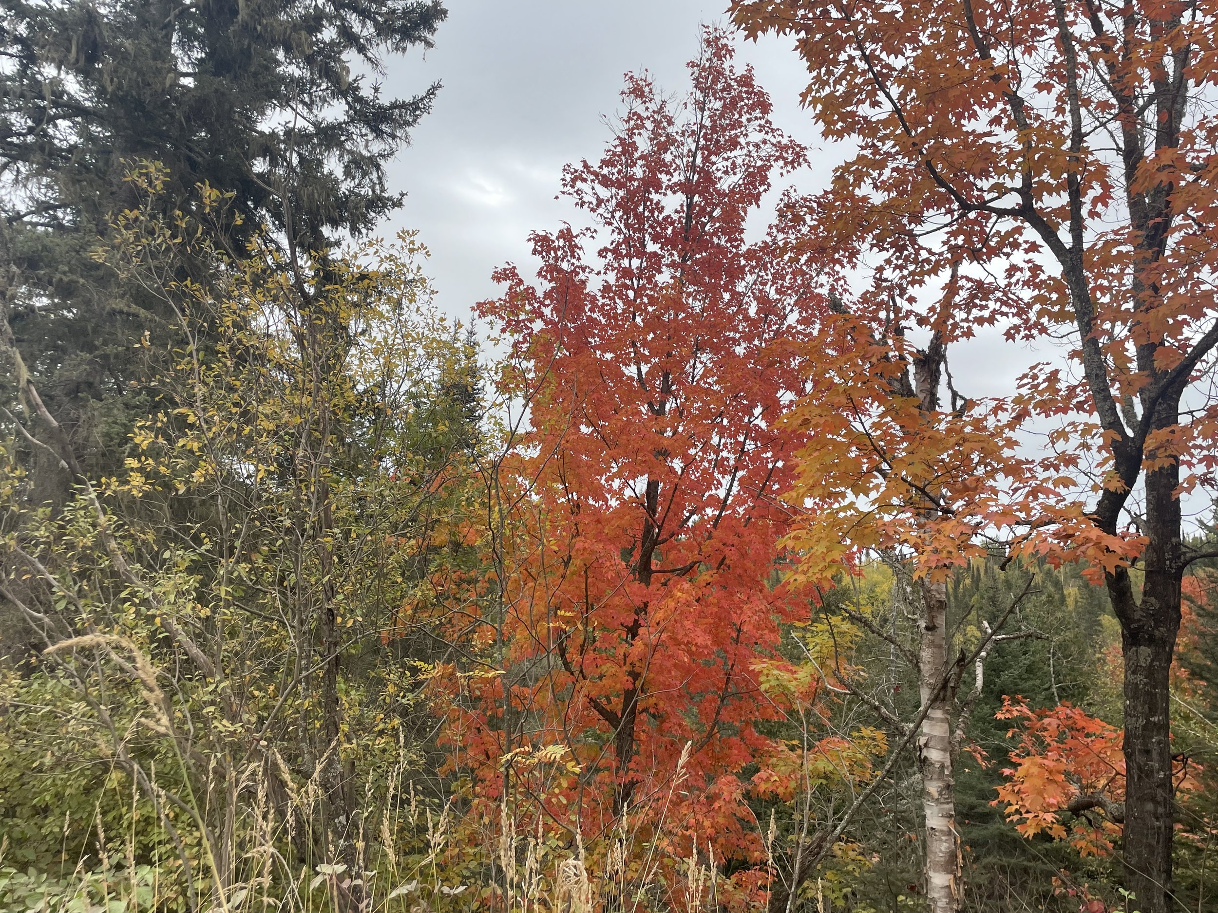
If a tree could shout, this one would be screaming Look at Me! The prettiest tree I saw the entire day. Same as the grouse, it gets a well deserved spot in this blog.

Cascade River viewed from the Pike Lake Road Bridge
This is one of two points in the Cascade River Loop Trail that I was thoroughly confused and not sure where to go next. After I crossed the bridge, I was expecting the trail to be on my right, where the river was. The trail goes over the road. It was the one spot not marked - I really could have used a sign. Walk to the Superior Hiking Trail parking lot, which is visible from the road. The trail will continue from the parking lot and it goes under the bridge.
I really liked Hidden Falls, but not everyone is going to want to hike 7-miles to see it, especially when there is a cheater shorter option available. Keep reading below in the Hidden Falls section for the second half of the Cascade River Loop trail. I’ve broken it out for those that want to just drive to the Superior Hiking trailhead.
Hidden Falls
There are two options to see Hidden Falls at Cascade River State Park. The first is hiking a 7-mile loop along the Cascade River Loop trail (scroll up to see this trail guide). The second is parking at the Superior Hiking Trailhead and walking 0.6 miles out-and-back. I’m guessing the latter is what most people choose.

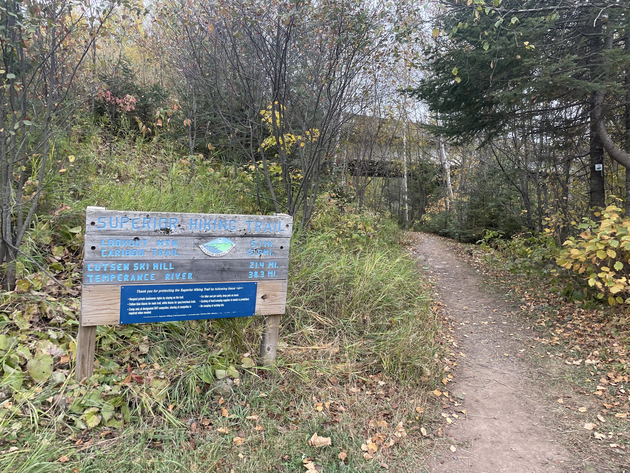
Parking is available at the Superior Hike Trail parking lot along Pike Lake Road, marked with the black star. The waterfall is marked with a pin, and the River Loop trail is highlighted in pink.
From the MN-61 parking lot in Cascade, it’s a 10-minute drive to the Cook County 45 Superior Hiking Trailhead. Going north on MN-61, turn left onto County Road 7 and drive for 2.4 miles. Turn left on Pike Lake Road. The SHT trailhead is the Cook County 45 Trailhead. Or use GoogleMaps and enter ”Hidden Falls” - pick the falls near Grand Marias, MN.
To see Hidden Falls head on, cross Pike Lake Road, go over the bridge, and hike 0.3 miles along the dirt path (elevation gain is about 75ft). Scroll up a few pictures for photos of Hidden Falls from this view.
I think the better option is to see Hidden Falls up close. At the parking lot, there is a Superior Hiking Trail map. Hidden Falls isn’t listed, but Lookout Mountain and Cascade Trail are. This is the right trail. It goes under the Pike Lake Road bridge.
Superior Hiking Trail marker - follow the trail under the Pike Lake Road bridge
It’s a short 0.3 mile relatively flat trail along the river to get to Hidden Falls.
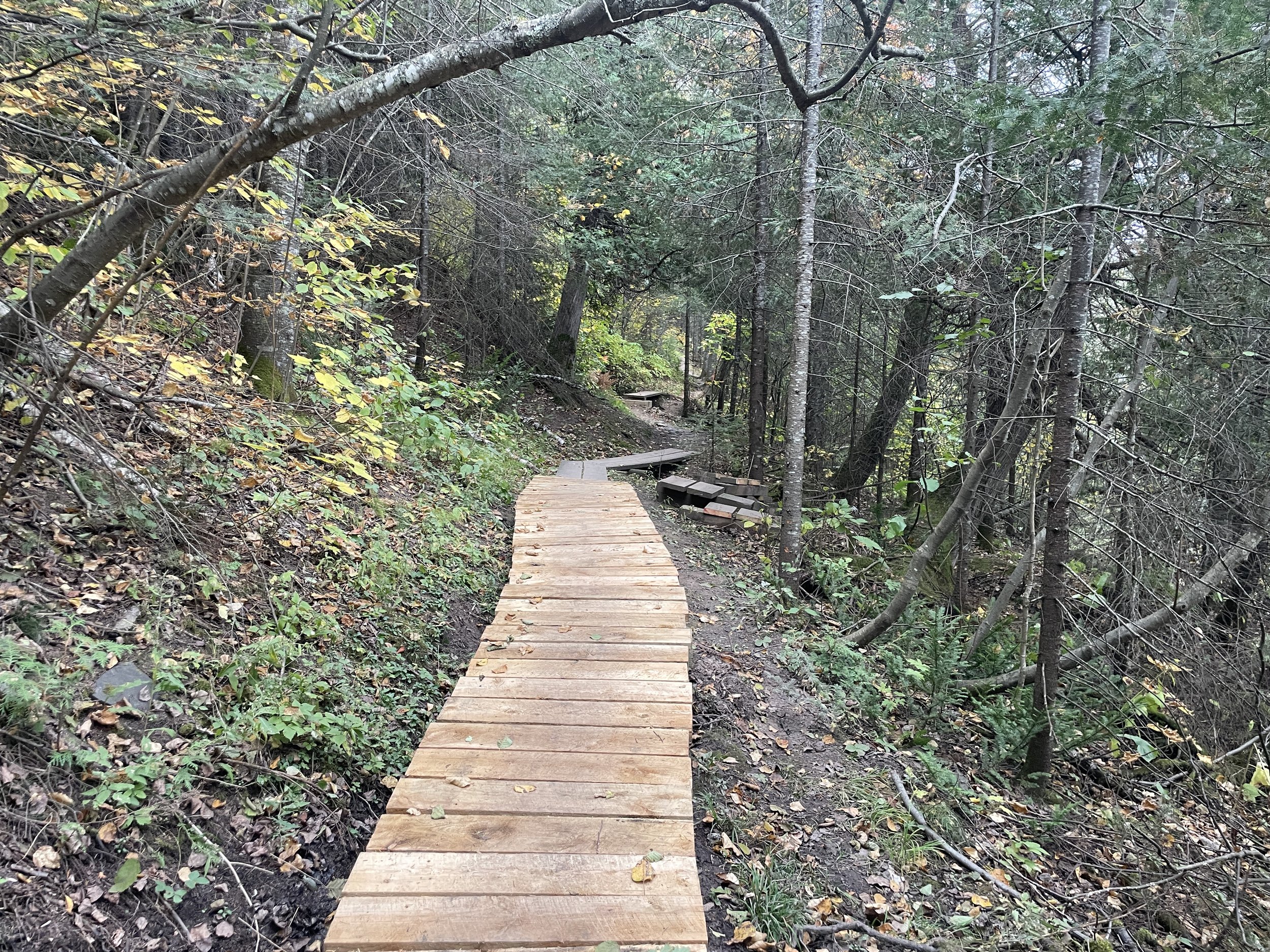
Another cool part of the walkway along the Superior Hiking Trail
The trail joins up with the river very quickly. This part of the hike is as nice as the spot below 96 steps along the other side of the River Loop Trail.

Cascade River above Hidden Falls
There are large portions of the riverbank that can be explored if the formal trail isn’t your thing.

Cascade River above Hidden Falls

Cascade River - Hidden Falls
The trail comes right out to the river next to Hidden Falls. There are a few steps to this waterfall.

Second step of Hidden Falls

Last part of Hidden Falls
Below Hidden Falls, the Cascade River Loop remains along the waters edge for quite a distance. I liked this portion of the trail. As I was hiking the entire 7-mile loop, I kept walking. For anyone just seeing Hidden Falls, this is the point to turn around.

Cascade River below Hidden Falls
As I mentioned, the trail continues by the water for the majority of the loop back. Once the trail starts heading up and veering left, it won’t rejoin the river until just before waterfalls.
I mentioned there were two places that I did confused along the River Loop Trail. There’s one spur trail about 0.2 miles before the main hiking bridge that goes down to the river. There’s a trail marker with a state park map, but it was a confusing trail intersection. Don’t go down to the river. Your knees have probably had enough up-down anyway. Stay on the main trail even though it’s marked funny. You will shortly rejoin the Lower Waterfall Loop and be back at the parking lot.

(Oct 2024) Gorgeous fall afternoon along Cascade River Loop Trail
Lookout Mountain
Distance / Elevation Gain - The shortest hiking option up and back from Lookout Mountain adds 1.7 miles to the Cascade Waterfall Trail and 375ft in elevation. This is a steeper and more rugged trail. This trail is marked in green.
The entire Hiking Club Trail at Cascade River State Park (which includes the waterfalls and Lookout Mountain, as well as a longer loop through the woods) is 3.2 miles with a total elevation gain of 670ft. This trail is marked in orange, green, and purple..

The shortest option to Lookout Mountain is an out-and-back along the green trail. Start on the Lower Waterfall Loop (orange) and the trail intersects on the west side of the river, just after the hiking bridge.
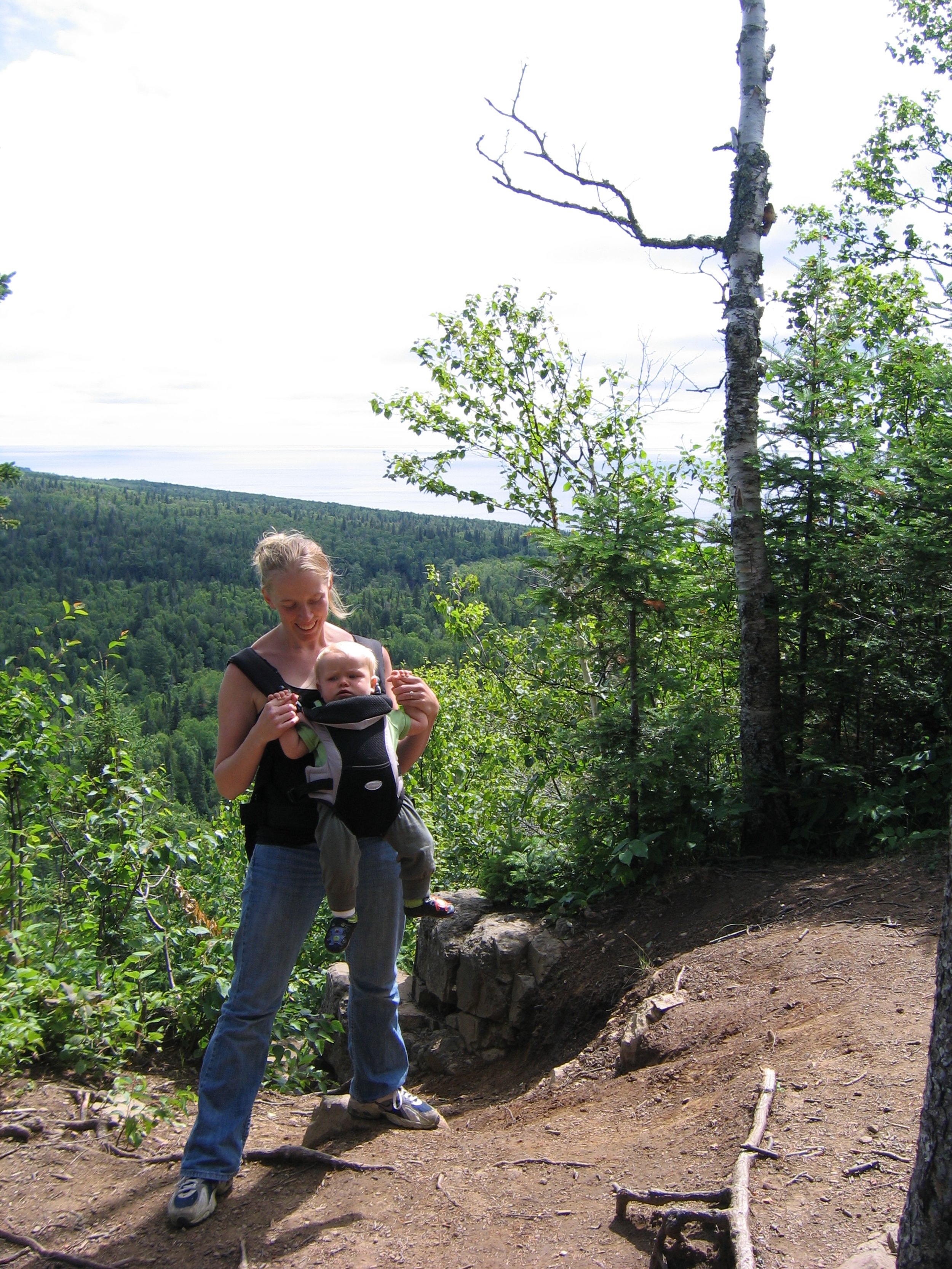
Our first time to Lookout Mountain was during a camping trip when our son was just 9 months old, and instead of hopping between State Parks, we enjoyed the whole weekend just in Cascade. With nothing to do on Saturday morning after breakfast, we wandered up here. That was a long time ago, but I didn’t remember anything remarkable about the trail.
I returned in October 2024, and I don’t think I will hike it again. For the MN Hiking Club Trail, it’s a tough hike. Sections of the incline are fairly steep. I hiked up it pretty fast and passed several hikers. I returned the same way back and the majority of the people I had passed had turned around without making it to the top.
As far as the view from the top - It’s one narrow section to look out at the valley and Lake Superior from, and unfortunately, the best view is from a rock that sticks out a bit. For anyone scared of heights, this isn’t the right hike. Also, there isn’t much for views along the rest of the trail. Unless you are collecting hiking club passwords, I would skip this hike, and I’d recommend Oberg Mountain, Britton Peak, Carlton Peak, or Mt. Baldy instead, all of which are easier and have better overall views (note Mt. Baldy does not have a view of Lake Superior, just lakes within Tettegouche State Park).

Hiking up to Lookout Mountain
Most of the trail to Lookout Mountain looks somewhat like the picture above. The trail ascends up, there are trees on both sides, and there isn’t anything too terribly remarkable about the hike up. There is one point near the beginning that includes a short bridge over a creek.

Trail to Lookout Mountain
View from Lookout Mountain - Cascade River State Park
The other peak hikes I listed above have multiple places to stand and to be able to look out and see the views from. Lookout Mountain has one viewing spot. And to get that much of Lake Superior in the picture, the photographer is going to need to walk out on the rock I have shown in the picture below. Anyone unwilling to be quite that brave will be left with a view of just a small corner of Lake Superior.

Shifting my body position just slightly to find more of Lake Superior ends up just with a view of pine trees

View from behind the rock at Lookout Mountain
Lookout Mountain several years ago
The pine trees were quite a bit shorter our first time up here, but even then the view wasn’t very inspiring.
The below picture is what the trail looks like to the left of the cliff - it’s just the trail and more forest. There isn’t another view.

Not old enough yet to walk on his own, we did all of the carrying. Even babies like to explore in the forest, and we stopped for bits to let him wander around with our help.

Dad’s preferred hiking style

Never too young to start your kids hiking. This is actually an easier stage than when they hit 3 and 4 and need to do the majority of the walking themselves. That’s a problem solved with interesting places to explore and appropriate bribery.
Lake Superior Shoreline Trail at Cascade River
Distance / Elevation Gain - There is an interesting rocky shoreline at Cascade River which creates an opportunity to walk north along the Lake Superior shore for up to 1.5 miles (one-way) with no change in elevation. This trail is marked in blue. There is a return option to make it a loop marked in red that is slightly longer. The Shoreline Trail is one of my favorite trails though along the North Shore, and I would suggest walking back along it. Enjoy the sound of the lake’s waves.
Other than the Superior Hiking Trail’s Lake Walk Trail, this is the only true hiking option along Lake Superior’s shoreline. The rest of the state parks just have short sections where Lake Superior can be explored.

Map of Cascade River State Park’s Lake Superior Shoreline Trail
Not meant to be an after-thought at the end of my blogpost, but Cascade’s Lake Superior Lake Shoreline Trail is its own hike. There’s not a way to cut back on mileage at Cascade River State Park and add the Lake Shoreline Trail into another hike. I’ll still recommend completing the waterfall loop, but the Shoreline Trail is one of my favorite hikes along the North Shore. My best advice - plan to spend some extra time in Cascade River State Park, and hike both the waterfalls and explore along the shoreline.
For anyone hiking the Lake Superior Shoreline Trail, there is one other option open for parking. If parking at the main trailhead off of MN 61 is full, drive approximately 0.25 miles and take the next pull off to the right. Parking is available along this entire small road. There are spur trails out to the Lake Superior Shoreline Trail. The Shoreline Trail connects with the main trailhead, so no extra walking is needed for anyone planning on heading this way anyway.
From the main trailhead off of MN 61, there are two staircases down to the lakeshore, one on each side of the bridge going over the Cascade River. The steps on the south side lead to a very small beach. I would recommend picking the steps on the north side, which is the beginning of the Shoreline Trail.

Steps down from MN-61 on the south side of the bridge

Looking back under the MN-61 bridge at Cascade River from the south side. This was Jan 2024. The beach was hardly existent when I re-visited in April.
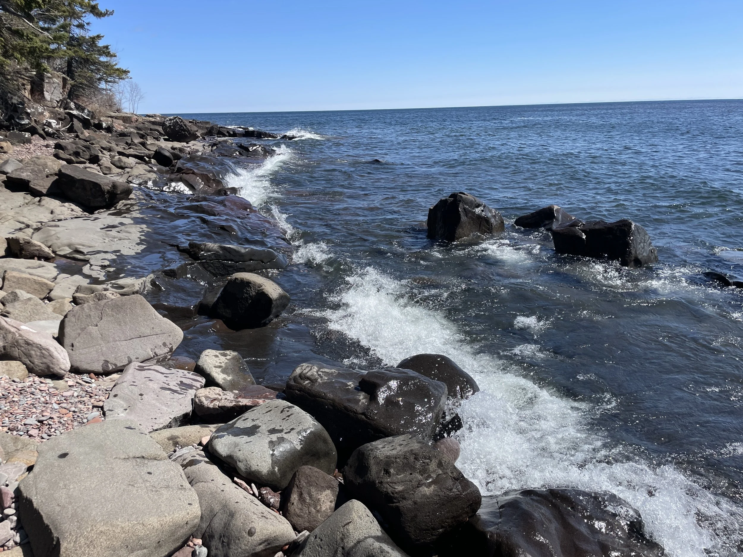
The Lake Superior Shoreline Trail has two options. The first is a dirt path that stays very close to the water’s edge. Lake Superior is visible from the majority of this trail. The second option is to skip the trail and hike directly along the water’s edge. Unless the waves are high, the majority of the hike can be completed along the rocks.

Cascade River’s Lake Superior Shoreline Trail

The Lake Superior waves were so high on my last trip out to Cascade in October 2024
Typically, I’ve observed Lake Superior to be calm. There are always waves as Lake Superior is so big, but typically they are small. And I simply appreciate the quiet sound of the waves stretching onto the rocks. In October 2024, these waves were quite large compared to what I’ve experienced before. I had fun scrambling along the rocks. On top of the higher rocks I was fine, but to quickly make it past the lower rocks, I had to time my journey with the waves to keep my feet dry. And there were some sections that I just couldn’t pass due to the height of the waves, and I needed to move to higher ground along the formal dirt-packed trail.

October 2024 - Large waves along Lake Superior’s Shoreline Trail
As cool as the Lower Waterfall Loop Trail is, I love this Shoreline Trail just as much. Cascade River is worth the extra drive north! An added plus is that it just isn’t near as busy as Gooseberry. The size of the parking lot naturally limits the number of people that can be here at the same time - but even then, I’ve never had an issue finding parking here.

Rock-hopping in April 2024, enjoying the sound of the waves, losing some of life’s stress along the Lake Superior Lakeshore Trail
More of the Shoreline Trail

Here’s a throwback picture from the 90s, hiking in Cascade with my parents and best friend. Adults - this is the whole reason to take your kids hiking and camping even though it takes a ton of effort to get out of your house. Teaching your kids to hike and camp enables them to go hiking and camping, and eventually will encourage them to take their kids. And so on and so on, and so on.

And here I am, in the same spot, teaching my son to walk on the banks of Lake Superior
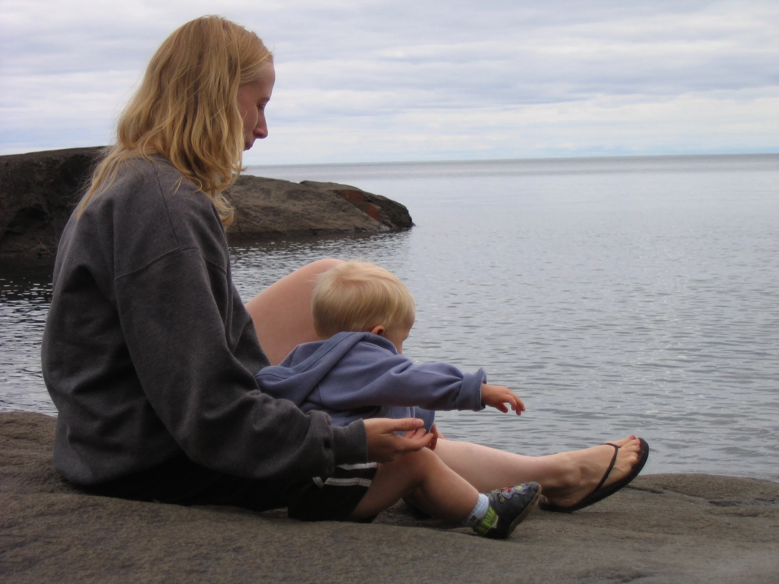
Hiking isn’t just about walking - it’s also about sitting, splashing in the water, throwing rocks, listening to the waves, taking your shoes off and feeling the earth beneath your feet, and simply breathing.
Other Outdoor Things to Do within an Hour Drive
Below are hyperlinks to other posts I’ve written about things to do that are located within an hour’s drive from Cascade River State Park
Lutsen Ski Resort
(north) Lutsen is the best ski resort in Minnesota. During the summer months, the gondola continues to run. There are hiking trails and a half-mile Alpine Slide.
Oberg Mountain
(south) This is overlook hike is part of the Superior Hiking Trail, and therefore parking is free. This is a busier trail, especially in the fall..
Temperance River State Park
(south) This is the most unique State Park along MN-61 where seven waterfalls can be seen in a hike less than 2 miles. Several of these waterfalls occur in dramatic pothole formations. The official MN State Park map undersells this state park, as does the size of the parking lot off of MN-61.
Sawbill Canoe Outfitter
(southwest) The closest entry to the Boundary Waters Canoe Area from MN-61 is Sawbill Lake. There is a canoe outfitter on the lake where canoes and other gear can be rented. There is a 4.5-mile three-lake trek for a single day exploration, and multiple options for multi-day canoe trips.
Sugarloaf Cove
(south) A privately owned section of Lake Superior with an interesting bay protected by rock formations. This park has a small fee and includes its own visitor center.
Caribou Falls State Wayside
(south) An easy hike to large but quiet waterfall..
George Crosby Manitou State Park
(southwest) This is a rustic, quiet, and less travelled MN State Park with one of the more impressive waterfalls in Minnesota.
Tettegouche State Park
(south) This is my favorite MN State Park. There are four waterfall hikes within the park, amazing views of Lake Superior along the cliffs above the water, secret beaches with sea caves, and more inland there are some incredible views from above of smaller lakes (especially gorgeous in the fall colors).
Bear and Bean Lake Loop
(south) Part of both the Superior Hiking Trail and Tettegouche State Park, the Bear and Bean Lake Loop is one of the most popular trails along the North Shore. The views are amazing, and the trail is fun to hike. Be warned though this is a 7-mile loop trail with an elevation gain of 900ft.
Black Beach
(south) This is a free beach on Lake Superior’s shoreline, lined with black rocks. There is an island that can be explored by foot. There are also tables right on the beach, making this my top recommendation for a picnic location.
Split Rock Lighthouse State Park
(south) Pebble Beach is my favorite place to stop and play along the North Shore, and I think the best place in Minnesota to skip rocks. Little Two Harbors is the best short trail to see the lighthouse up close. Split Rock River is the best long trail with small waterfalls and views of Lake Superior. Day Hill is a shorter trail with views of Lake Superior.
Iona’s Beach
(south) This is a free beach on the Lake Superior shoreline, full of beautiful pink rocks.
Gooseberry Falls State Park
(south) Hike to three amazing waterfalls in 1.3 miles. Additional hikes included within the link.
Eagle Mountain
(north) The highest point in Minnesota can be accessed from the BWCA along a 6.5 mile out-and-back trail. This is an easy trail until the last 1/3 of the trail ascends 500ft dramatically. A permit is required, but it’s free, and the paperwork is available at the trailhead.
Grand Marias, MN
(north) My favorite pizza along MN-61 is at Swen & Ole’s Pizza in Grand Marias.
Lake Walk - Superior Hiking Trail
(north) The only section of the Superior Hiking Trail that is along Lake Superior’s shoreline is the Lake Walk, a 1.5 mile stretch of sand / loose gravel, just south of Judge Magney State Park. Note that this is an awesome beach, but a hard place to hike long distances due to the soft ground.
Judge C.R. Magney State Park
(north) This park has two large waterfalls - Upper Falls and Devil’s Kettle.
Grand Portage National Monument
(north) When visited in the summer months, this National Monument includes an interactive fort that depicts the life of British fur traders from the 1780s. Outside of the fort is an exhibit on the Ojibwe Native Americans, which is open year-round.
Grand Portage State Park
This park borders Canada and includes the tallest waterfall in Minnesota. The hike to this waterfall is handicap accessible. There are also two smaller waterfalls along a more rugged, (and slightly swampy) trail.
Link to Full North Shore Guide from NatureImpactsUs.com
For more ideas of things to do up and down MN-61 along Lake Superior, visit my North Shore Guide.
Other Hiking Ideas
If you are looking for more hiking suggestions, please check out my below map which has additional posts linked to each pin.