Last Updated January 2026

Lake Powell & Glen Canyon National Recreation Area - Hanging Garden Viewpoint
If you enjoy my blog, please consider signing up below for email notifications of my latest posts. I will not share your email address.

Toadstool Hoodoos (upper picture) & White Pocket (lower picture)
Planning a Vacation in Page, Arizona
If you’re looking for an off-the-beaten-path vacation with beautiful hikes, adventure, and minimal crowds, Page, AZ, might have what you are been dreaming about. Nearby are stunning slot canyons, hoodoos, arches, areas to explore with 4x4 vehicles, and places to swim, kayak, and rent house boats. Page sits just north of the official start to the Grand Canyon (as determined by the National Park Service), next to a dammed-up portion of the Colorado River, which forms Lake Powell.
Where is Page, Arizona?
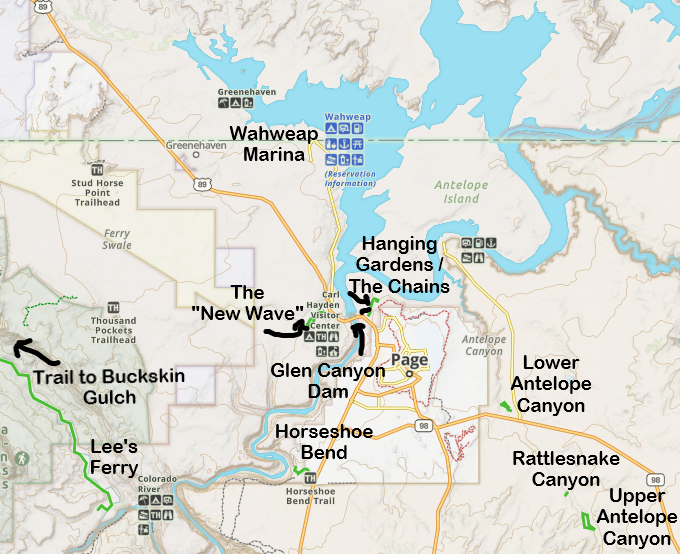
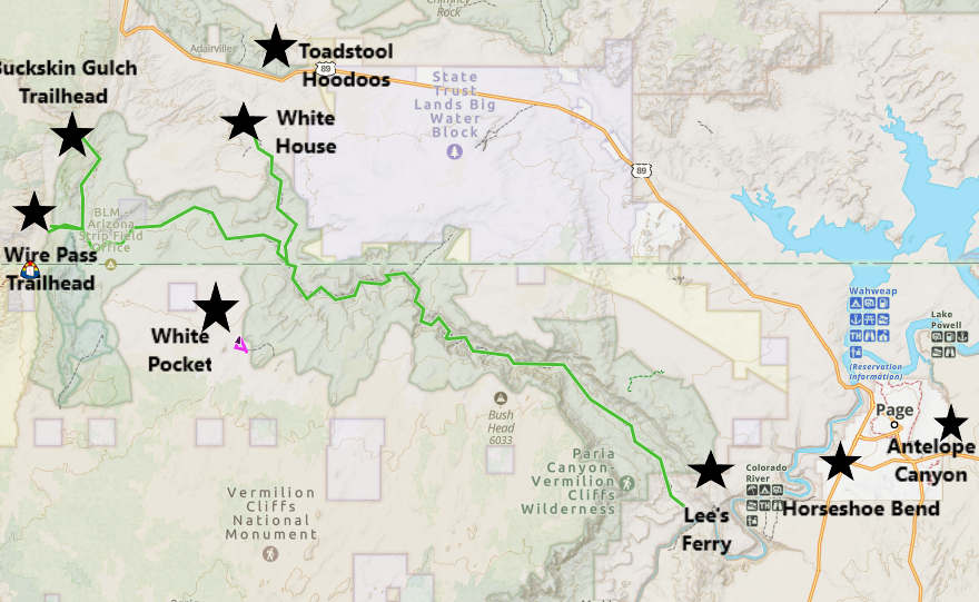
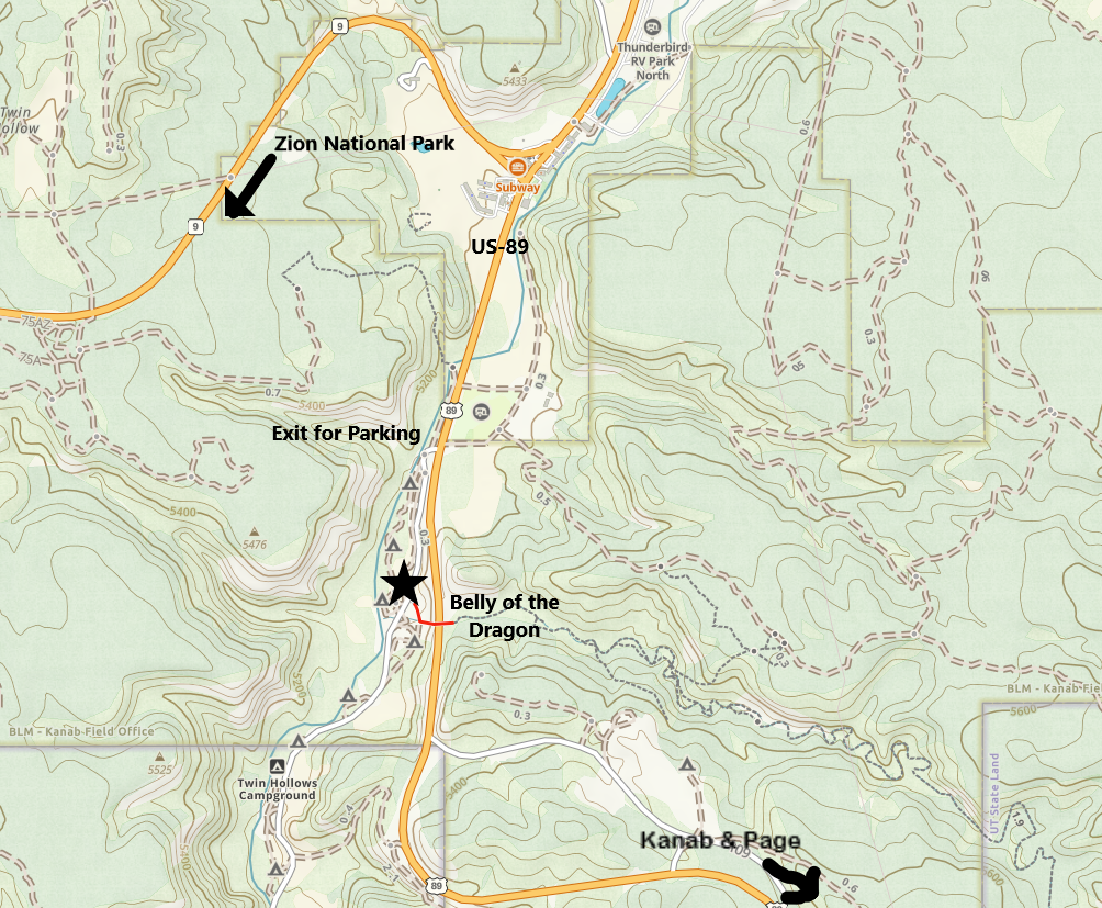
The reason Page remains a quiet town despite having some incredible tourist features is that it takes some considerable driving effort to get to it. Below is a map showing where Page is located, as well as cities with International Airports, and other National Parks, any of which could be combined into a larger road trip.
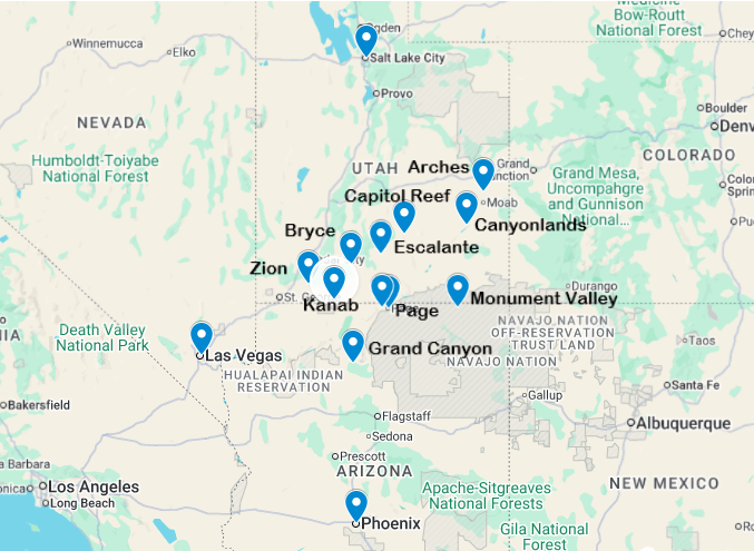
Map of Page with nearby large cities with airports and other National Parks that may be combined into a larger road trip
Situated on the northern edge of Arizona, Page is a 4-hour drive from Las Vegas, 4.5 hours from Phoenix, and 5.75 hours from Salt Lake City. A road trip to Page can be combined with several National Parks, though, making it well worth the effort to drive there. Grand Canyon, Zion, and Bryce National Parks, as well as Monument Valley Tribal Park are all with 3 hours or less from Page. Escalante is about 3.5 hours from Page. Capitol Reef, Arches, and the Needles portion of Canyonlands are 4.5 hours away, while the Island in the Sky portion of Canyonlands is a 5-hour drive. (Note that I’ve been to the Grand Canyon several times as well, but the only post I have written to date is hiking Rim-to-Rim-to-Rim, and I still need to create a guide for easier hikes and viewpoints in the park).
I have one other place flagged on the above map, and that’s Kanab, Utah, a really small town - even smaller than Page. The distance between Page and Kanab is 75 minutes. Kanab is located closer to Zion National Park. For someone that wants to spend a few days hiking in Zion, and is interested in seeing say Antelope Canyon, putting a toe in Lake Powell or just taking its picture, and maybe hiking Toadstool Hoodoos and / or Buckskin Gulch, and maybe even taking a tour of White Pocket, I would actually recommend staying in Kanab and just do one or two day trips to the Page area. (Packing up hotel rooms, especially trying to do so with younger kids, is not much fun… especially when you have to do it multiple times during a road trip.) Toadstool, Buckskin Gulch, and White Pocket are located mid-way between Page and Kanab. There really isn’t a need to switch hotels. The benefit in staying in Page, though, is that it’s a little more modern than Kanab - the hotels are bit newer and nicer, and there are more restaurants (both chain and local) when compared to Kanab. Page is too far from Zion to plan more than one day trip.
If you are deciding between Kanab and Page, it also depends on where else you want to go. Page is an hour closer to the Grand Canyon, Monument Valley, and Moab (Arches and Canyonlands). Kanab is an hour closer to Escalante.
Lodging and Logistics
Despite being a smaller town, Page has several hotels and rentable homes. There are a couple of campgrounds but do note that it gets above 100 deg F in the summer months, which might make for a miserable camping experience. A unique option (that my family has talked about several times but hasn’t yet tried) is to rent a houseboat on Lake Powell.
Weather is one of the main considerations when travelling to Page. Summer months are hot - in the triple digits. Swimming, kayaking, or hiking in a canyon through water (ex. Buckskin Gulch) are perfect ideas - at the right time of day considering sun exposure. Long desert hikes are not the best summer options. In the winter it does get below freezing, but highs are often in the 40s or 50s. We’ve stayed in Page three times. Twice in March with fantastic weather - not hot or cold. We were also stayed a night in June 2026 breaking up the drive between the Grand Canyon and Zion, and we just wanted to spend a couple of hours laying on floaty mats in Lake Powell. June is the perfect month to do such a thing!
One other consideration is how many nights to stay in Page. Excluding houseboat rental (which could be fun to do for water-lovers for an extended period of time), I would say 2-3 nights would be enough for most people. The first day would probably just be driving to Page, then hit an Antelope Canyon Tour, the Glen Canyon Dam and Visitor Center, and New Wave (better known as the Beehive) or Hanging Gardens. The next day check out Horseshoe Bend and as you leave, stop at Toadstool Hoodoos. For those that like longer hikes or want to book a 4x4 tour, spend that third night and do a full day hike Buckskin or reserve a tour to see White Pocket.
Things to Do In or Near Page, Arizona
In the map below, I have hyperlinks so you can jump to different sections within the post. At the end of each section there is a link back to the map. Simply reading the post top to bottom is also an option. I also have links to separate posts that I’ve written, with more information about each place to visit.
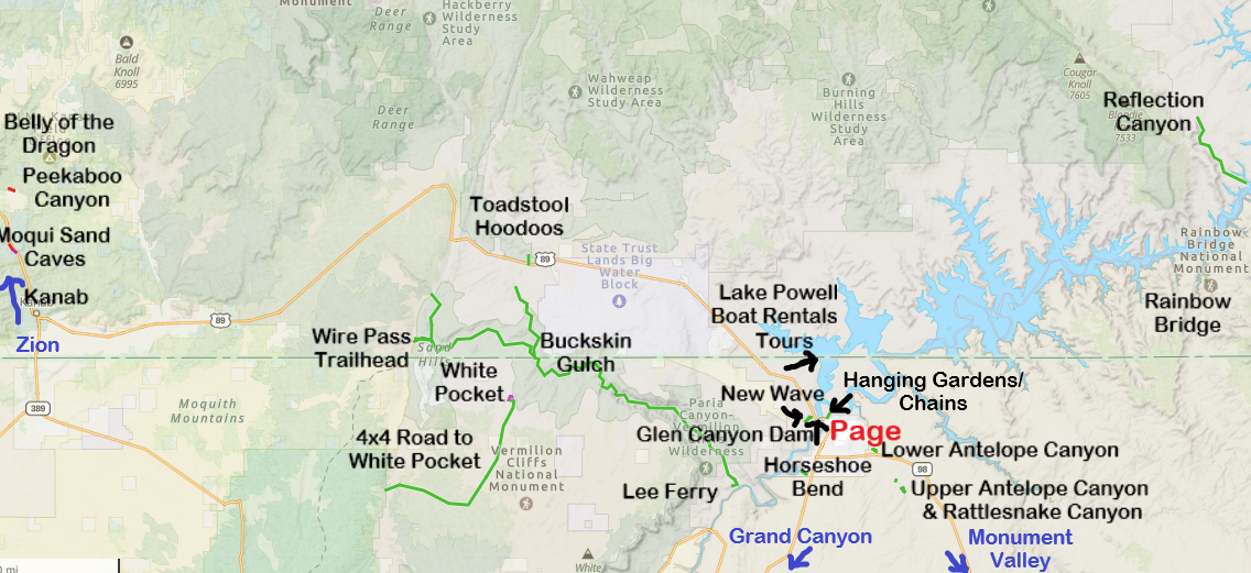
1 - Antelope Canyon / Rattlesnake Canyon - Antelope Canyon and Rattlesnake Canyon are slot canyons that require purchasing a ticket and using a tour guide. The hikes are relatively easy, although some tours require steps or use of a ladder. Tickets are expensive, but this slot canyon is incredible.
2 - Horseshoe Bend - The hike out-and-back to Horseshoe Bend is an easy trail, but there is no shade. Additionally, the trail out descends the entire way, making the trek back to the car more difficult. Bring extra water.
3 - Glen Canyon Dam - There is a visitor center right next to the Glen Canyon Dam with a short video explaining its construction. From the visitor center, it’s a short walk to the dam, and there is a pedestrian bridge for better viewing.
4 - Lake Powell (Wahweap Marina) (including a boat tour to Rainbow Bridge) - Swimming, renting a kayak for a few hours, renting a houseboat for a few days, and / or taking a boat tour (including an option of a longer trek all the way out to Rainbow Bridge water-level permitting) are all options to play in and around Lake Powell
5 - Hanging Gardens / The Chains - The trail to Hanging Gardens is about a mile out-and-back with an option to go to a viewing area for Lake Powell. The view of Lake Powell is the reason to do this hike! The Chains has a trailhead right next to Hanging Gardens. There is an option to swim at this trailhead or just explore along the slick rock.
6 - New Wave / Beehive - There is a 1.2-mile loop hike at New Wave, right next to the Glen Canyon Visitor Center. It’s the best spot near Page to climb on rocks.
7 - Toadstool Hoodoos - The hike out-and-back to Toadstool Hoodoos is about 1.8 miles long, depending on how far one explores the hoodoos. There is minimal elevation change, parking is right off of the highway. This trail does not have shade. Bring extra water.
8 - Buckskin Gulch (Wire Pass Trailhead) - The most common trailhead for Buckskin Gulch, the longest known hikeable slot canyon in the world, is Wire Pass. Permits are required (but there are no limits for the number of day-use permits, so they can be purchased on the day of the hike). It’s 1.7 miles to reach Buckskin Gulch from the Wire Pass trailhead. Once in Buckskin Gulch, the slot canyon stretches for 20 miles to White House (for a through hike option) or 46 miles to Lee’s Ferry (also as a through hike). Note that overnight permits are limited and hard to obtain.
9 - Lee’s Ferry - Lee’s Ferry signals the start of Grand Canyon National Park. The access point to the Colorado River can be reached by car. This is a starting point for kayaking upstream (floating down) or whitewater rafting. This is also the exit point of a complete through hike of the Buckskin Gulch Canyon.
10 - White Pocket - White Pocket is an easy 2 mile-ish hike in an incredible, otherworldly landscape. To access White Pocket, a 4x4 vehicle is required, as well as knowledge of how to drive in deep sand. Tours to White Pocket are options for those of us without 4x4 vehicles or who don’t know how to drive in sand.
11 - Moqui Sand Caverns (also known as Kanab Sand Caves) - This is a short hike (little less than a mile out-and-back) with a very steep and somewhat sketchy sandstone hill to climb to get to a manmade cave. The best time for pictures is late in the afternoon.
12 - Belly of the Dragon - Belly of the Dragon is an amazing manmade water culvert under US-89 that is being carved slowly into a slot canyon by the water moving through the sandstone. Roundtrip trail is 0.25 miles.
13 - Kanab’s Peekaboo Canyon - Peekaboo is a short, beautiful, and easy 1.0 mile out-and-back slot canyon near Kanab (not to be confused with the Peekaboo Slot Canyon in Escalante). This canyon does require an off-road vehicle to get to the trailhead. Vehicles can be rented in Kanab or ask a tour guide to take you there.
14 - Reflection Canyon - Reflection Canyon is a “wish list” hike for me that I’ve included as it’s part of Lake Powell. It’s accessed however from the north side, near Escalante, down the slightly treacherous Hole-in-the-Rock Road. This is an 18-20 mile out-and-back hike. It is also possible to reach the canyon by water, from Lake Powell, and scramble up the canyon wall.
15 - Zion National Park - The east entrance of Zion National Park is not quite 2 hours from Page. Note that most visitors want to go to the west side of the park, which requires an additional 30-minute drive. For anyone wanting to spend more than one day in Zion, switch lodging to St. George, Springdale, or Kanab.
16 - Monument Valley Tribal Park - Monument Valley is about 2 hours from Page. This is worthy of a day-trip from Page. Or consider switching lodging. There is a hotel just across the road from the park entrance.
17 - Grand Canyon - It’s about 2.5 hours to the South Rim Visitor Center. I’d recommend switching lodging and staying in Grand Canyon Village to fully experience the Grand Canyon.
1 - Antelope Canyon / Rattlesnake Canyon
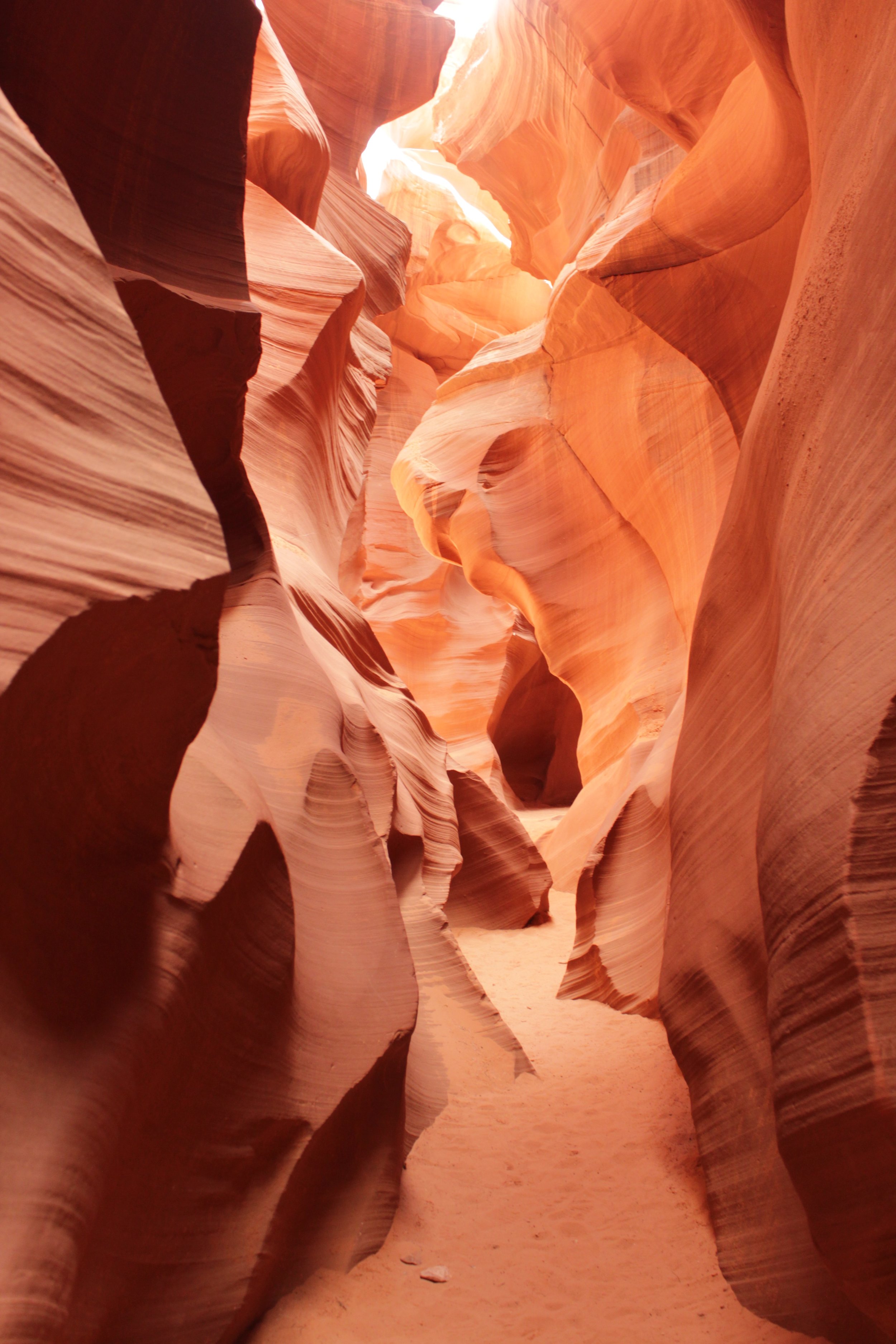
Lower Antelope Canyon
Antelope Canyon is a tight slot canyon with incredible colors and rock shapes that play with your imagination. It’s one of the most beautiful places I have found myself in. Because Antelope Canyon is a slot canyon, when it rains, flash floods can occur within the canyon. On Aug 12, 1997, eleven hikers were killed in a flash flood within Antelope Canyon. As a result of this, to ensure future hiker safety while within this Tribal Park, the only way to get into this canyon is on a guided tour.
The guided tours are a bit pricey; however, the tour guides will help set up your camera with proper settings so you will get the best possible pictures, and that alone I thought made the price worth it. That, and the canyon is just simply incredible.
The tours are not very big, and this is a popular activity in Page, so consider booking your tickets ahead of time.

Lower Antelope Canyon
Where is Antelope Canyon / Rattlesnake Canyon?
Antelope Canyon is located just to the east of Page, Arizona. There are different starting locations based off of which tour you pick, so pay attention to the information on your ticket. Lower Antelope Canyon tours start within walking distance to the canyon. Upper Antelope Canyon tours start within the city of Page and include a van ride out to the trailhead. There is a third section of Antelope Canyon referred to as “Rattlesnake Canyon”. These tours have a start location off of AZ-98 and also involve a van ride to the trailhead.
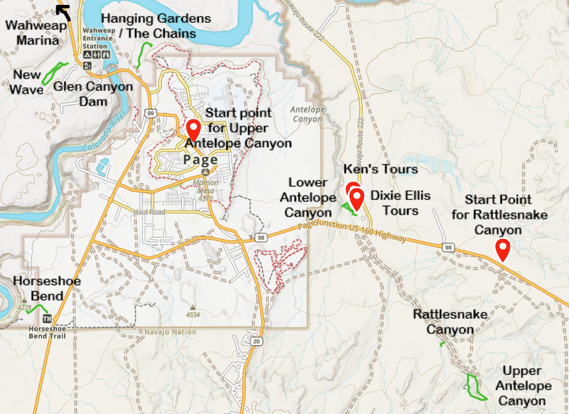
Tour locations for Antelope Canyon / Rattlesnake Canyon
Antelope Canyon Tours
There are two tour options for Lower Antelope Canyon. Ken’s Tours can be purchased at: https://lowerantelope.com/. Dixie Ellis Tours can be purchased at: https://www.antelope-canyon-tours.com/. We booked through Ken’s Tours. Our guide was great! The tour lasted a little over 60 minutes and involved the use of stairs, which had railings.
Tickets for Upper Antelope Canyon can be purchased at: https://www.antelopecanyon.com/, and tickets for Rattlesnake Canyon can be purchased at: Rattlesnake Canyon Tour - Adventurous Antelope Canyon Tours.

Lower Antelope Canyon
More Information on Antelope Canyon / Rattlesnake Canyon Tours
For more information on the logistics of visiting Antelope Canyon, including additional pictures and more information on the tour options, refer to my post on Antelope Canyon.
2 - Horseshoe Bend
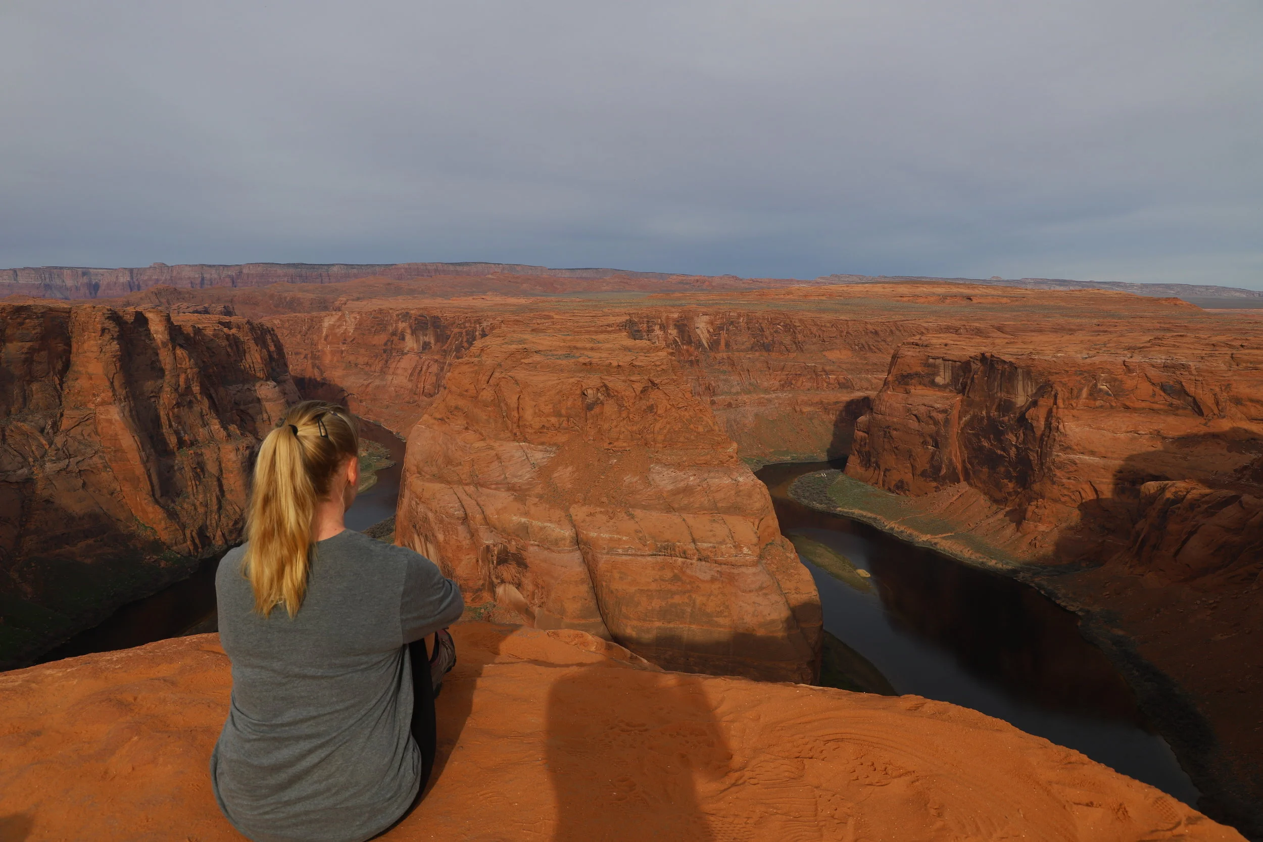
Horseshoe Bend
Horseshoe Bend is an iconic viewpoint along the Colorado River. Not officially part of the Grand Canyon National Park (which does not start until slightly south at Lee’s Ferry, about 18 miles down the river), Horseshoe Bend is actually part of the Glen Canyon National Recreation Area. That does not mean its view is any less worthy than those within the National Park boundaries.
Where is Horseshoe Bend?
Horseshoe Bend is about 15 minutes south of Page, directly accessible off of US-89.

Map to Horseshoe Bend
Hiking at Horseshoe Bend
The trail down to the Horseshoe Bend viewpoint is relatively easy, with a nice wide path, mild elevation change, and it’s only a 1.5 mile out-and-back hike. However, there is no shade along the trail, and it’s going to be a steady incline to get back to your vehicle. Make sure to bring water and consider hiking when the temp is cooler and the sun is not at peak intensity.
More Information About Horseshoe Bend
For more information regarding the logistics of visiting Horseshoe Bend, please see my post on Glen Canyon National Recreation Area. I have the link set to the section within the post that’s about Horseshoe Bend.
3) Glen Canyon Dam & Visitor Center

Glen Canyon Visitor Center - Junior Ranger Pledge
Where is the Glen Canyon Dam & Visitor Center?
The Carl Hayden Visitor Center for the Glen Canyon Dam is located just off of US-89, on the west-side of the Colorado River (before the bridge that takes you into the main part of Page). Parking at the visitor center is free.
What Can You Do at the Glen Canyon Dam?
There is a short movie in the visitor that explains how and why the Glen Canyon Dam was constructed. Then you can walk from the visitor center over the bridge and look over at the dam. For anyone interested in working on Junior Ranger badges, there are two opportunities - for both Glen Canyon as well as Rainbow Bridge. It took us less than 30 minutes to complete both. Rainbow Bridge is accessible from Lake Powell (depending on water levels) but note that this is a full-day boat ride, which might be hard for squirrely younger children.
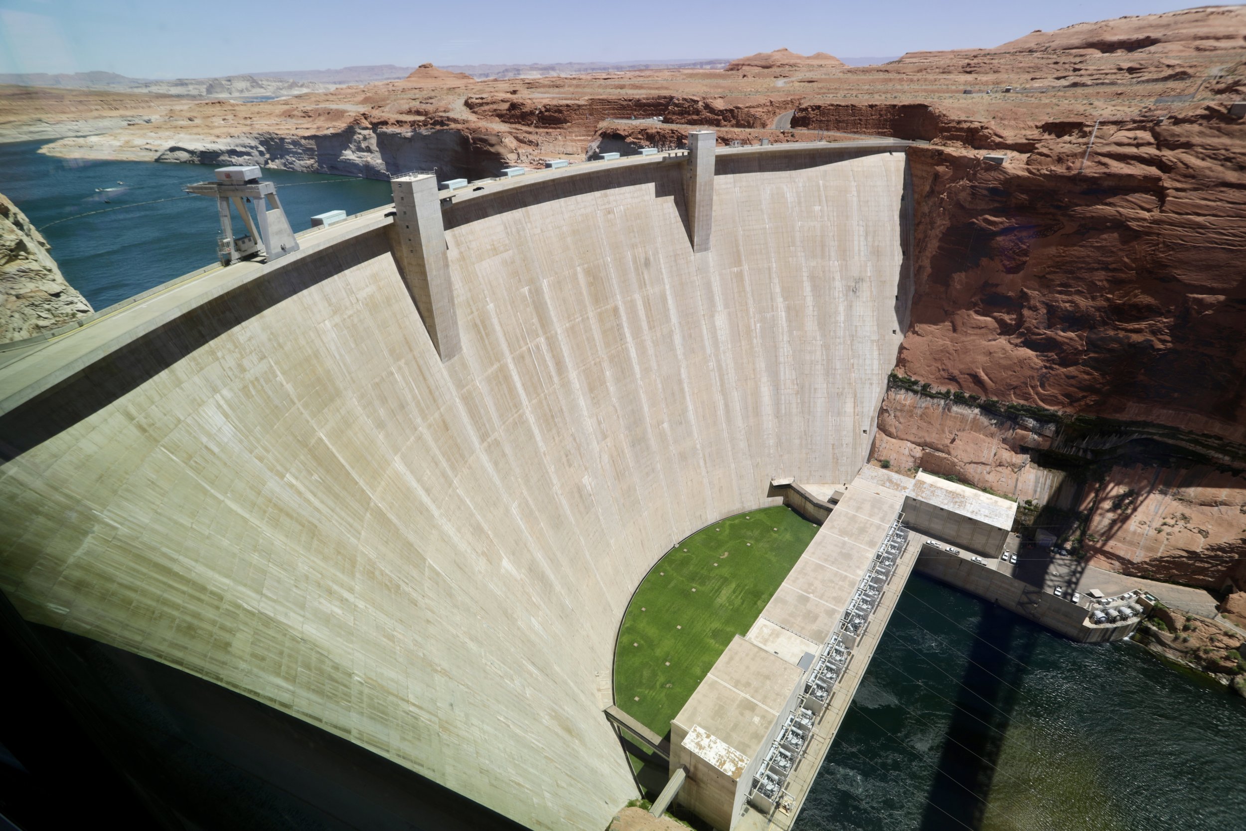
Glen Canyon Dam (June 2026)
More Information on the Glen Canyon Dam & Visitor Center
There’s not really more information than what I have above, but these same details are also shared in my post on the Glen Canyon National Recreation Area (linked to the section on the dam and visitor center).
4 - Lake Powell - Boat Rental, Tours, Swimming & Wahweap Marina

Lake Powell
Lake Powell is a flooded canyon, created by the Glen Canyon Dam. Its primary purpose is water regulation to the lower states (Arizona, Nevada, and California) and to ensure that the Colorado River water is not overused by the upper states (Colorado, Utah, Wyoming, and New Mexico). The resulting lake is more than 161,000 acres with 1,900 miles of shoreline, and a max water depth of 583ft.
Where is the Wahweap Marina?
The Wahweap Marina is on the west side of the Colorado River, about a 15-minute drive from the middle of Page. From US-89, turn onto Lakeshore Dr / Wahweap Blvd.
The Wahweap Marina is within the Glen Canyon National Recreation Area, therefore, there is a vehicle fee. If you have the America the Beautiful Pass, parking is free. The Marina includes both boat rentals and a swimming beach.
Where to Swim on Lake Powell?
To get to the Wahweap Swimming Beach, on the main road, continue past both the marina and the picnic area. You will see a sign for the swim beach right before the turn. Go through the first parking lot. If you need to use bathrooms, stop here. Keep going past the parking lot onto the gravel road which ends in a parking area. There’s a short trail (with some slight elevation to climb on the way back to your car).
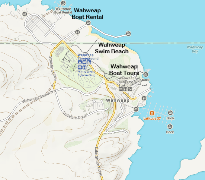
Map of Wahweap Marina - including boat rental, swimming beach, and the start of boat tours
There’s a nice beach area. In the summer, the sun is going to be pretty intense. Several people thought to bring shade tents when we were there, which seemed like a smart idea. We packed floaty mats on our road trip, and just played in the water the whole time.
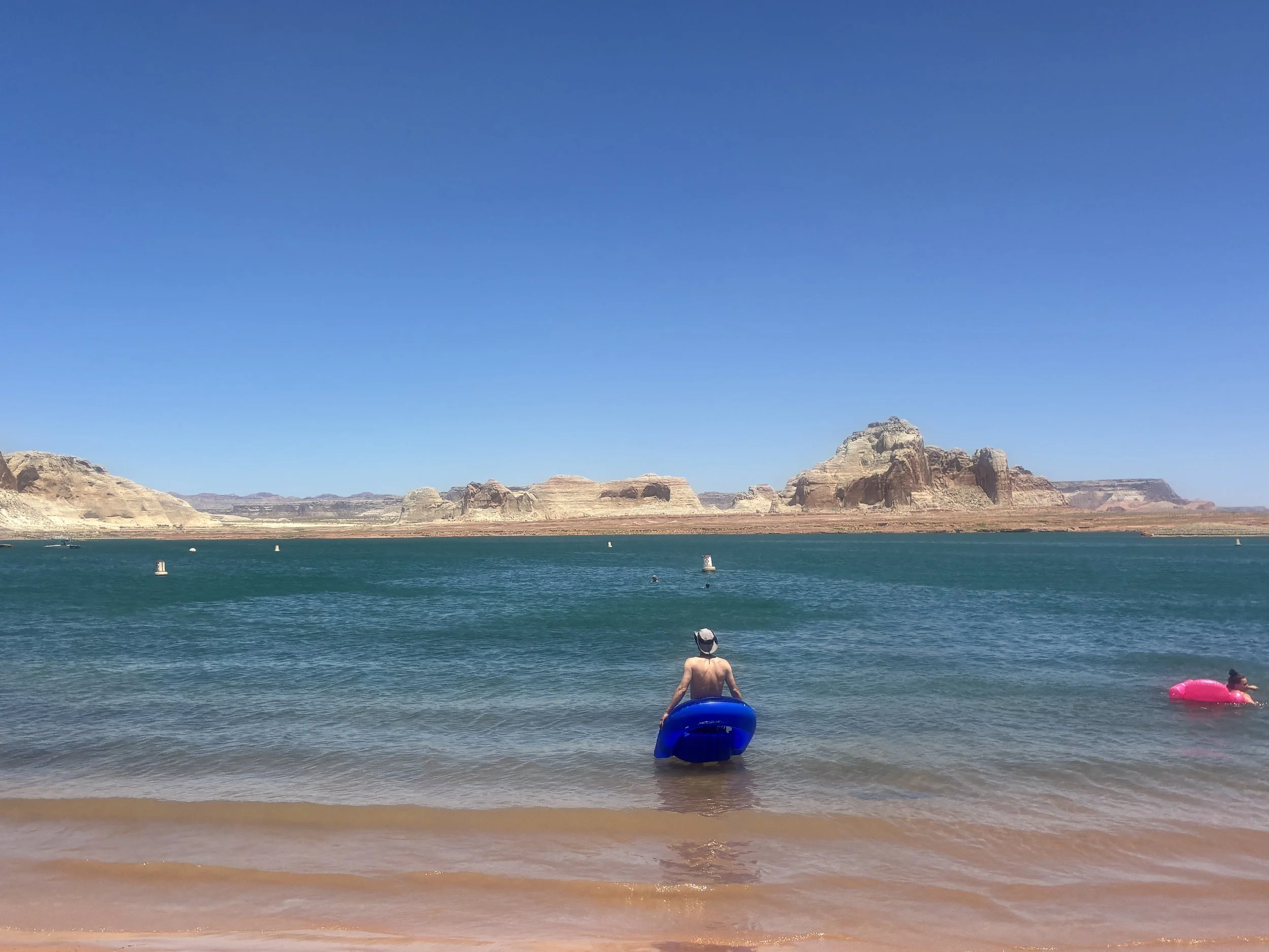
June 2026 - Chillin’ on Lake Powell with our floaties
Where to Rent Boats on Lake Powell?
Kayaks and houseboats can be rented at the Wahweap Marina. The best place to kayak, however, is into Antelope Canyon. Check out the Antelope Point Marina for kayak rentals.
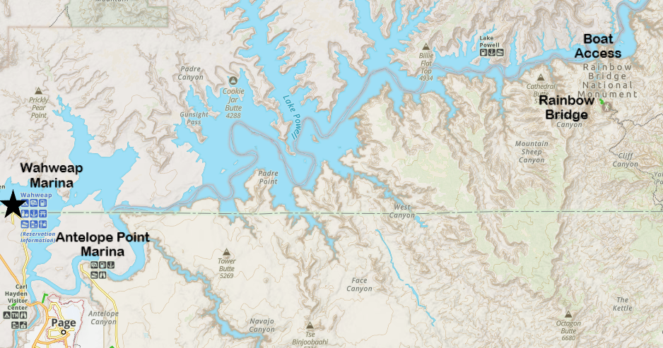
Map of Lake Powell and the marinas - including where the boat dock is located for Rainbow Bridge
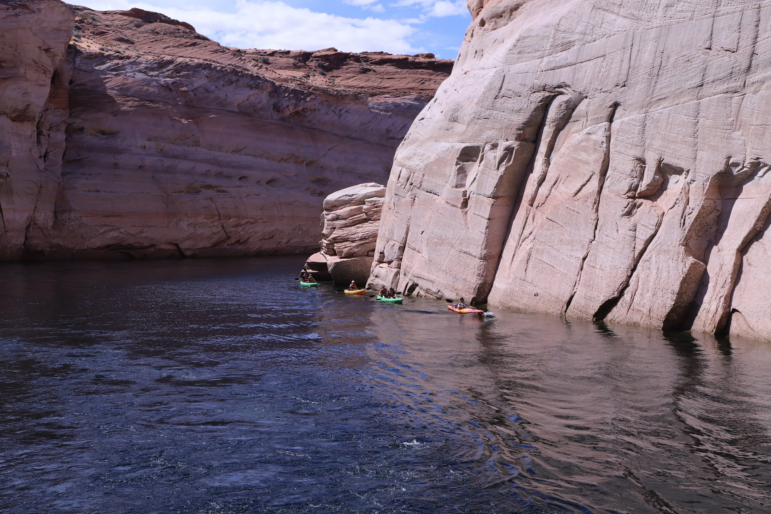
Kayaking into Antelope Canyon on Lake Powell
What Boat Tours are Available on Lake Powell?

Lake Powell - Antelope Canyon
Boat Tours are provided by Lake Powell Resorts & Marinas: https://www.lakepowell.com/things-to-do/boat-tours/. You can make reservations through this site.
To get to the boat tour launch, park in the main lot for the Lake Powell Resort (hotel). Go inside the main building of the resort and there will be a desk where the boat tours take off from.
We did the Canyon Adventure Tour, which was 2.5 hours long. My boys were 6 and 10 years old when we did this boat ride, and if I were to do this again, we would have booked the shorter 1.5-hour Antelope Canyon Tour. We all enjoyed being on the water surrounded by the impressive canyon walls, but 2.5 hours was a long time for the boys to sit.
There is also an option to take a full day boat tour out to Rainbow Bridge (water-level permitting).

Lake Powell - Boat Tours
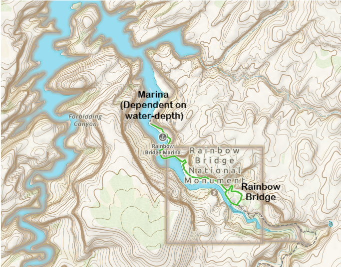
Where is Rainbow Bridge? How do you get there?
As long as the Lake Powell water levels are deep enough, sign up for the full day boat tour (see the link above, it’s the same company). The boat will start at the Wahweap Marina and travel out to a boat access / dock near Rainbow Bridge.

Lake Powell Map to Rainbow Bridge
From the boat dock, it’s approximately a 2 mile out-and-back hike. I haven’t had a chance to do this hike yet - my kids weren’t old enough to sit happily on a boat for that long.
More Information on Lake Powell
For more information on Lake Powell, things to do, additional logistics, and more pictures, visit my post on the Glen Canyon National Recreation Area (linked to the section on Lake Powell).
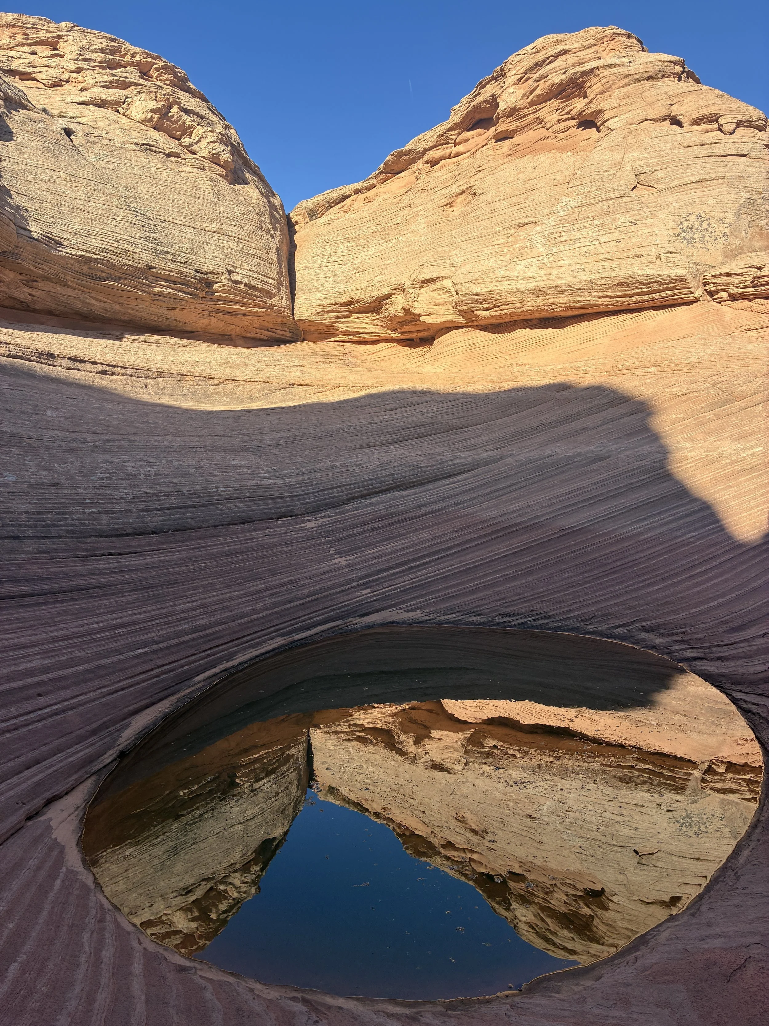
5 - Hanging Gardens & The Chains

Hanging Gardens Hike - Glen Canyon National Recreation Area
Where are the Trailheads for Hanging Gardens and the Chains?
The trailhead to Hanging Gardens is just a short drive off of US-89, on the east side of the Colorado River, just 5 minutes north of Page. To get to the Chains, don’t go back to US-89. Stay on the side road. The drive is just a few minutes from Hanging Gardens. Any car will be able to drive along this road.

Map to Hanging Gardens and the Chains at Glen Canyon National Recreation Area
Hiking at Hanging Gardens
The trail to Hanging Gardens is 0.6 miles-out-and-back with minimal change in elevation. The Hanging Gardens are interesting, but the reason to hike out here is to see views of Lake Powell. Take the spur up to the Viewpoint - which is a little bit just like walking up slickrock rather than a formal trail. It adds about 0.4 miles to the hike.

Hanging Gardens Hike - Viewpoint
Hiking & Swimming at the Chains

Glen Canyon - The Chains
We didn’t try swimming here; we just explored the Chains area by foot. It was just my boys and I while we were here watching the sun set. They had so much energy from sitting still on the boat tour that I just let them run up and down the hills, while I sat on the rocks, enjoying the sun, and enjoying watching them play.

Glen Canyon - The Chains
For More Information on Hanging Gardens & The Chains
For more information on these hikes, including maps and additional pictures, visit my post on the Glen Canyon National Recreation Area (linked to the section on the Hanging Gardens).
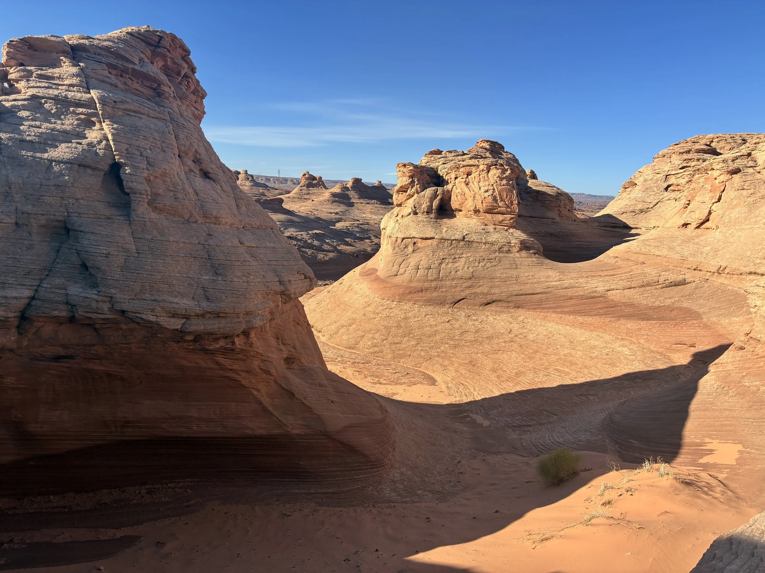
6 - New Wave / Beehive Loop
Where is New Wave / Beehive Loop?
Being honest, in 2019, I tried to find the New Wave (better known as Beehive Loop), thought I was there, and I’ve since realized I found the Chains…. (see above). I have since actually found it on a more recent return trip to Page. The trailhead is on the west side of the Colorado River, past the Glen Canyon visitor center and just before the Wahweap Marina.
New Wave / Beehive Loop Map
Hiking at New Wave
New Wave is a 1.2-mile loop hike with an elevation gain of 175ft. This is a fun easy hike, and there are lots of places to scamper up into the rocks to have better views.
More Information on New Wave (Beehive Trail)
For more information on New Wave (Beehive Trail), including a map and additional pictures, visit my post on the Glen Canyon National Recreation Area (linked to the section on New Wave / Beehive Trail).
7 - Toadstool Hoodoos
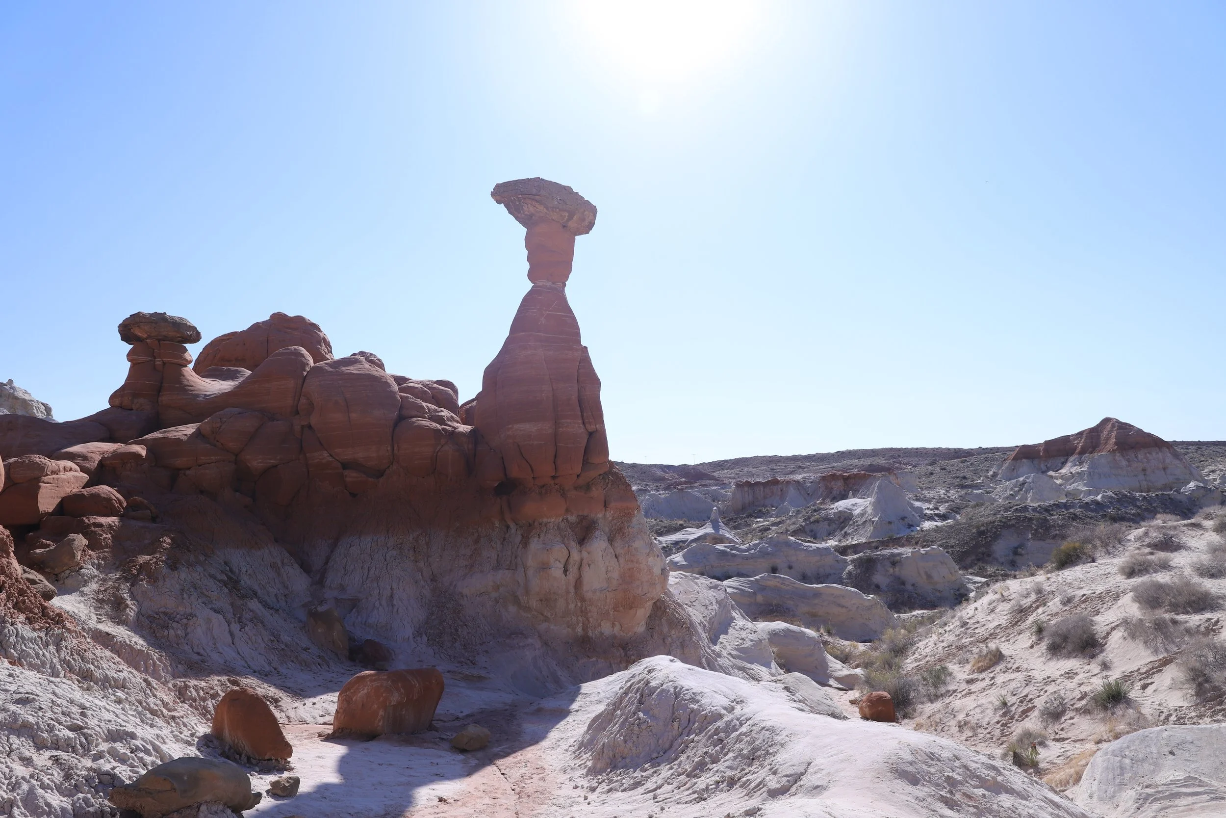
Toadstool Hoodoos - Grand Staircase-Escalante National Monument
For anyone visiting Page, the Toadstool Hoodoos should have the same priority to visit as Antelope Canyon and Horseshoe Bend. This is a free and easily accessible trailhead, and an easy hike. Just make sure to bring extra water with you and hike in the morning if you are visiting in the summer months.
Where are the Toadstool Hoodoos?
The trailhead to the Toadstool Hoodoos is approximately 30 minutes west of Page and is located directly off of US-89. This trailhead is also close to the turn-off point from US-89 for Buckskin Gulch.
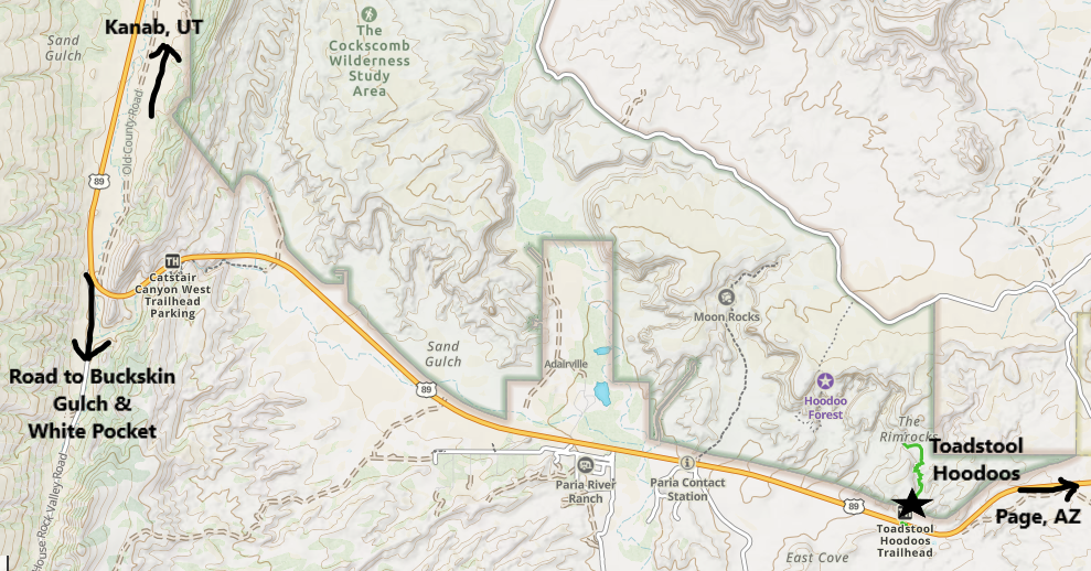
Map of the Toadstool Hoodoos Trailhead Location
Hiking at the Toadstool Hoodoos
The trail out-and-back to the Toadstool Hoodoos is about 1.8 miles long with an elevation gain of just 100ft. I say “about” as you might want to explore the hoodoo area further than we did. This is an easy hike to some amazing rock formations!
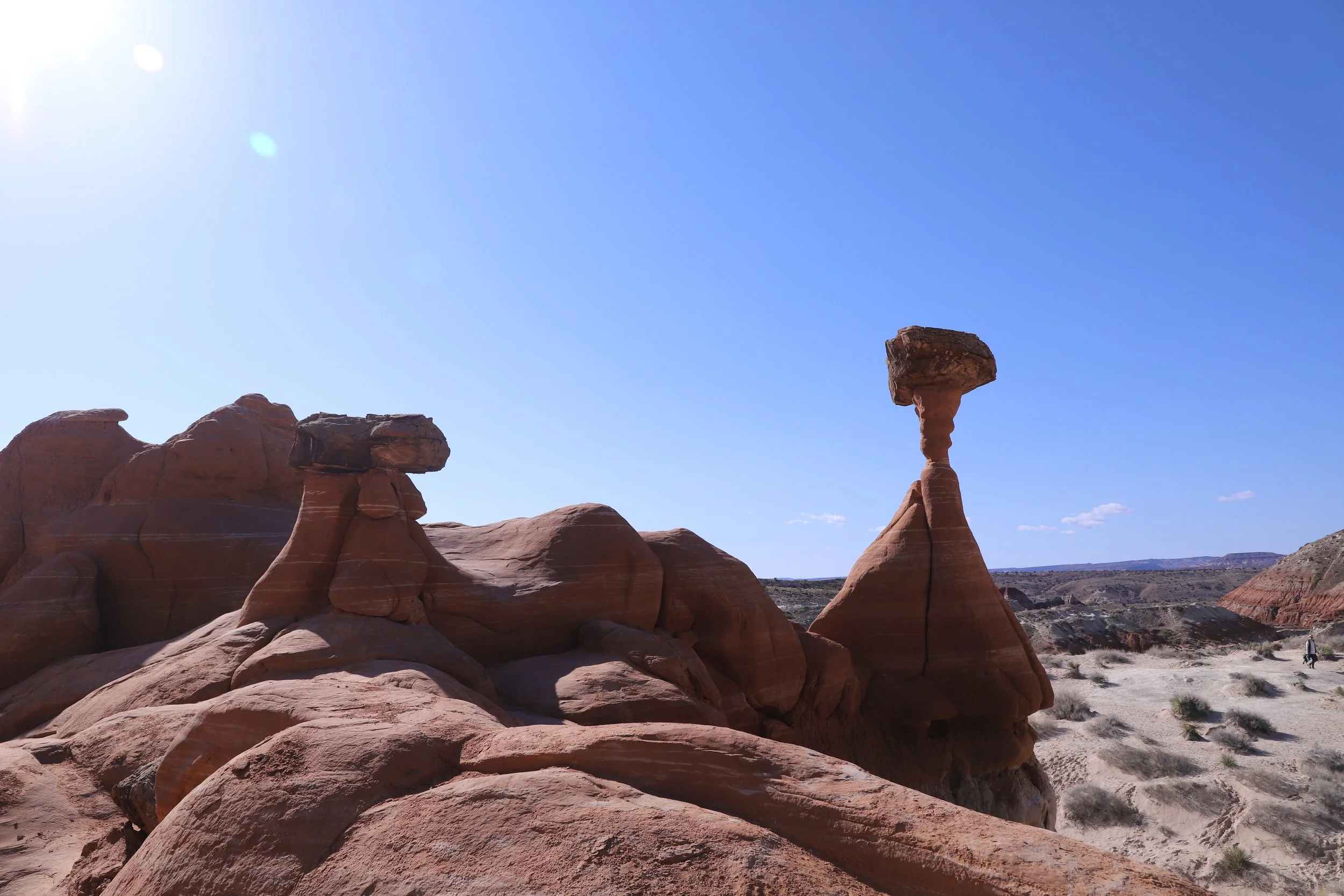
Toadstool Hoodoos - Grand Staircase-Escalante National Monument
More Information on the Toadstool Hoodoos
For more information on hiking to the hoodoos, including a trail map and additional pictures, see my post on the Toadstool Hoodoos.
8 - Buckskin Gulch (Wire Pass Trailhead)

Buckskin Gulch - Bureau of Land Management
Approximately 16 miles long, Buckskin Gulch is currently the longest known, hikeable slot canyon in the world.
Where is Buckskin Gulch?
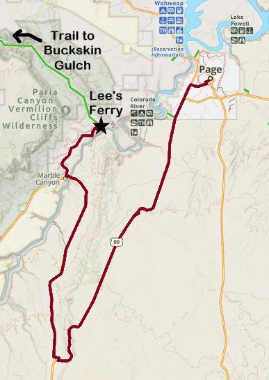
There are two primary entry points - Buckskin Gulch Trailhead and Wire Pass. For anyone backpacking, there are two additional exit points at White House and Lee’s Ferry. The primary trailhead is Wire Pass, which is about an hour drive, west of Page. From US-89, turn on The Cockscomb / House Rock Valley Road. The other entry point, Buckskin Gulch Trailhead is off of the same road from US-89, about 4 miles before reaching the Wire Pass Trailhead.
Lee’s Ferry is the exit point for anyone hiking the entire 46-mile journey. Although Lee’s Ferry is only about 18 miles south of Page following the river, there are no direct roads. This results in a 45-minute drive from Page.
Map of Buckskin Gulch and its trailheads
Hiking at Buckskin Gulch
There are several hiking options within Buckskin Gulch, most involving an out-and-back day hike. Note that day-use permits are required, but are unlimited, so they can be purchased the day of your hike. The overnight permits are hard to obtain and require pre-purchase.
The main trailhead, Wire Pass, requires a 1.7 mile hike (one-way) from the parking area to a T-intersection within Buckskin Gulch, from which you can wander into the slot canyon in either direction. Note that the first 1.4 miles of this trail are completely exposed in the sun, which is going to be a hot trail in summer months. Hike early in the morning.
It’s a 4.8-mile hike (one way) between Wire Pass and Buckskin), a 20-mile hike between Wire Pass and White House, and a 46-mile hike between the Buckskin Gulch Trailhead and Lee’s Ferry. One-way hikes require two cars or a pre-planned shuttle (there are several tour companies that provide shuttles). Out-and-back hikes are more flexible, obviously, as you can turn around whenever you’d like.
There is no guided hike option, like Antelope Canyon, and no one is going to prevent you from hiking into Buckskin Gulch when it isn’t safe. Please watch the weather for water (rain or snow) starting several days in advance. All water that falls in the canyon’s watershed is going to end up in this extremely long slot canyon. The only points to exit the canyon are the trailheads. Four hikers died in this canyon in 2023 due to flash floods.
Lastly, expect water on this trail. We hiked in the middle of June and there were several spots with water chest-deep. Clothes will dry out quickly in the desert but realize it’s unlikely you’ll stay dry in this canyon.

Hiking through Buckskin Gulch
More Information on Buckskin Gulch
For more information, including a trail map and additional pictures, here is my post on Buckskin Gulch.
9 - Lee’s Ferry
Lee’s Ferry marks the starting point along the Colorado River for Grand Canyon National Park. Due to the 45-minute drive from Page, I’ll admit that we haven’t put the effort into going to Lee’s Ferry yet. But I’m including reference to it here due to its significance both for hiking the full length of Buckskin Gulch, and because of its importance as the starting point of the Grand Canyon.
Where is Lee’s Ferry?
Although Lee’s Ferry is only about 18 miles down river from Page and the Glen Canyon Dam, there is no direct path by car. This site can be accessed from US-89 and then turning onto Lee’s Ferry Road, resulting in a 45-minute drive.
What is there to do at Lee’s Ferry?
At Lee’s Ferry, there are opportunities to hike, fish, rent kayaks, and take whitewater rafting tours, in addition to visiting historic sites. There are kayaking tours available that include an option through Horseshoe Bend. We haven’t made it here yet. Hopefully on a future trip, I’d like to hike through Marble Canyon and the Cathedral Wash Trail.
10 - White Pocket
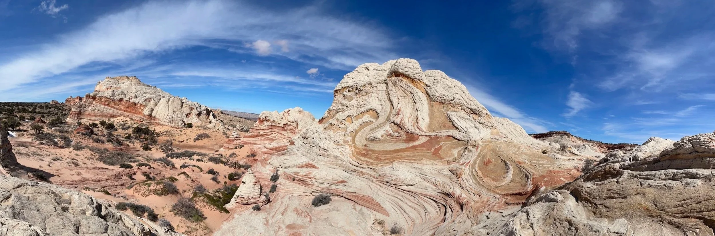
White Pocket - Vermilion Cliffs National Monument
White Pocket is probably the furthest “off-grid” that I’ve ever been before, and this desolate yet breathtaking place is worth the full-day adventure and hassle for getting here. It’s unlike anywhere else that I’ve been so far.
Where is White Pocket?
From Page, to get to White Pocket, take the same road as the trailheads for Buckskin Gulch, but keep going much further past. Eventually there is an unmarked sandy road that requires both a 4x4 and knowledge of how to drive in deep sand. There are a handful of unmarked turns required to arrive at the White Pocket trailhead.
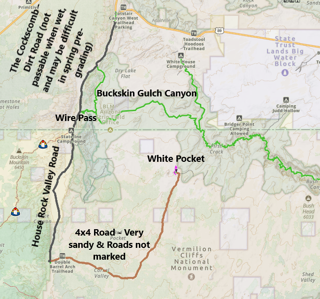
Getting to White Pocket
The easiest way to get to White Pocket (which doesn’t require 4x4 vehicle rental or ownership, nor knowledge and practice of driving in sand) is to pay someone else to take you there… Normally, I’m the one that gives advice on how to do slightly crazy things. This one, I’m just going to advise spending the money. The desert is not a safe place to get stuck or lost. We booked a tour with Paria Outpost & Outfitters. I would very much recommend their tour.
Hiking at White Pocket
Once you get to White Pocket, it’s a free place to hike with no permits required. You can easily wander 2+ miles without too much change in elevation, although a lot of the hike is along rock surfaces, so hiking poles might be helpful. This was a full day with the tour. It’s about a 2 hour drive each way, with 3 or so hours of hiking. To get more of the day, you could ask the tour company to pick you up / drop you off at the Wire Pass Trailhead to combine with a hike (if you are visiting in the summer and have more hours of daylight). Combining with the Toadstool Hoodoos is another great option.

White Pocket - Vermilion Cliffs National Monument
More Information on White Pocket
For more information and logistics on visiting, as well as additional pictures, here is my post on White Pocket.
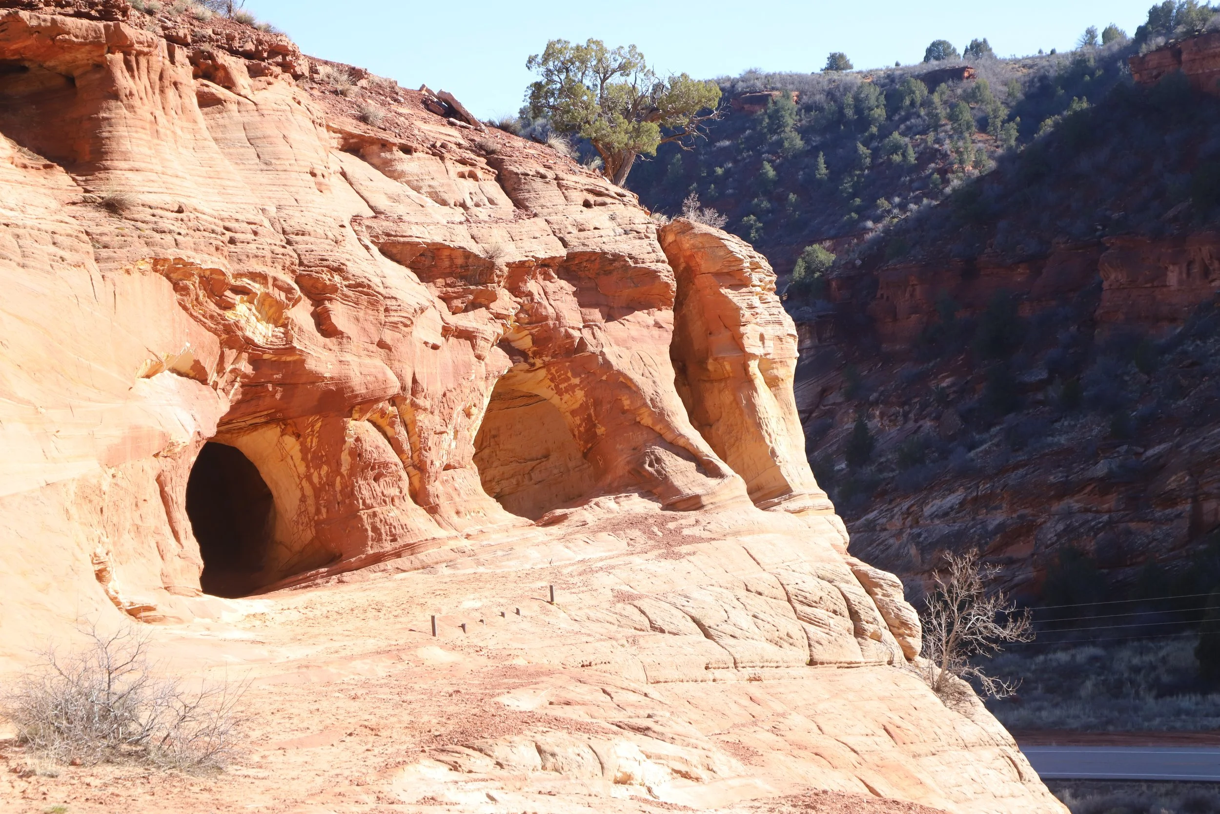
11 - Moqui Caverns (also known as Kanab Sand Caves)
Personally, I’d recommend hiking within Zion National Park over the Moqui Caverns (Kanab Sand Caves), but for anyone interested, there is a manmade cave dug into the side of a cliff along US-89.

Moqui Caverns (Kanab Sand Caves)
Where are the Moqui Caverns (Kanab Sand Caves)?
The manmade cave is located just off of US-89, about 10 minutes north of Kanab, Utah, and 30 minutes east of the east entrance to Zion National Park. From Page, this cave is about a 75-minute drive. I don’t think the drive from Page would be worth it on its own; but combined with a day of hiking in Zion National Park, it might be a fun side stop on the way back, if there’s daylight left.
Note that if you are interested in hiking more than one day in Zion, consider getting a hotel instead in Kanab, and do a day trip out to Page. Or consider switching hotels.

Map of Moqui Caverns (Kanab Sand Cave) location
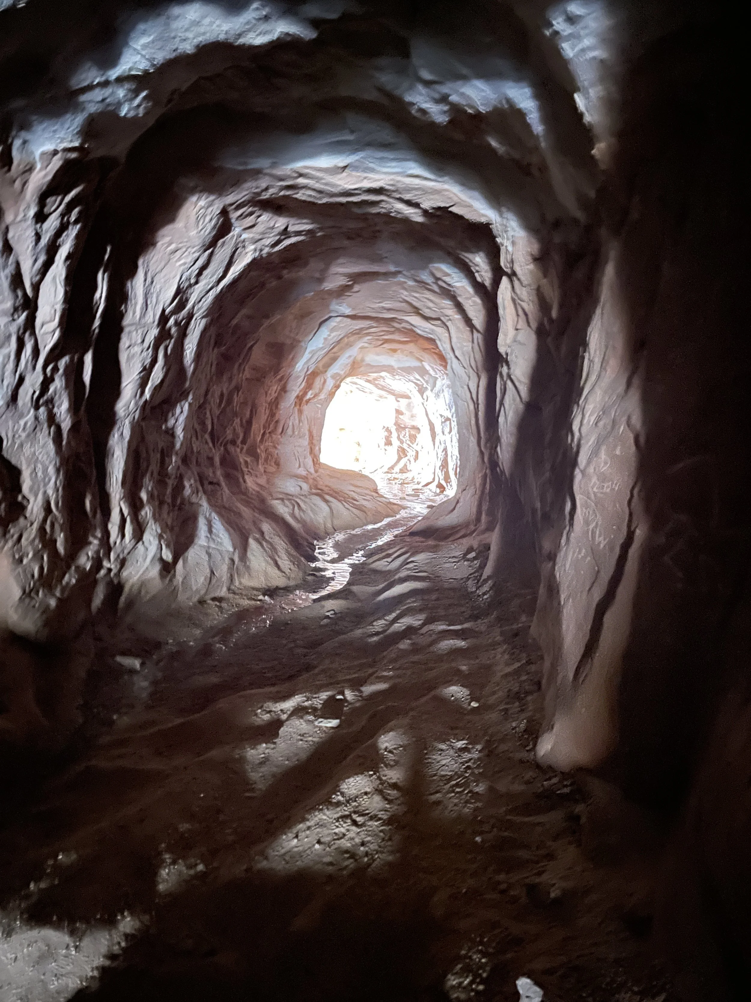
Hiking at the Moqui (Kanab) Sand Caves
This is a short hike (little less than a mile out-and-back) with a very steep and somewhat sketchy sandstone hill to climb to get to a manmade cave. The best time for pictures is late in the afternoon.
Moqui Caverns (Kanab Sand Caves)
More Information on the Moqui Caverns (Kanab Sand Caves)
For more information on the hike, including a map, specific places to park, and additional pictures, here is my post on the Moqui Caverns (Kanab Sand Caves).
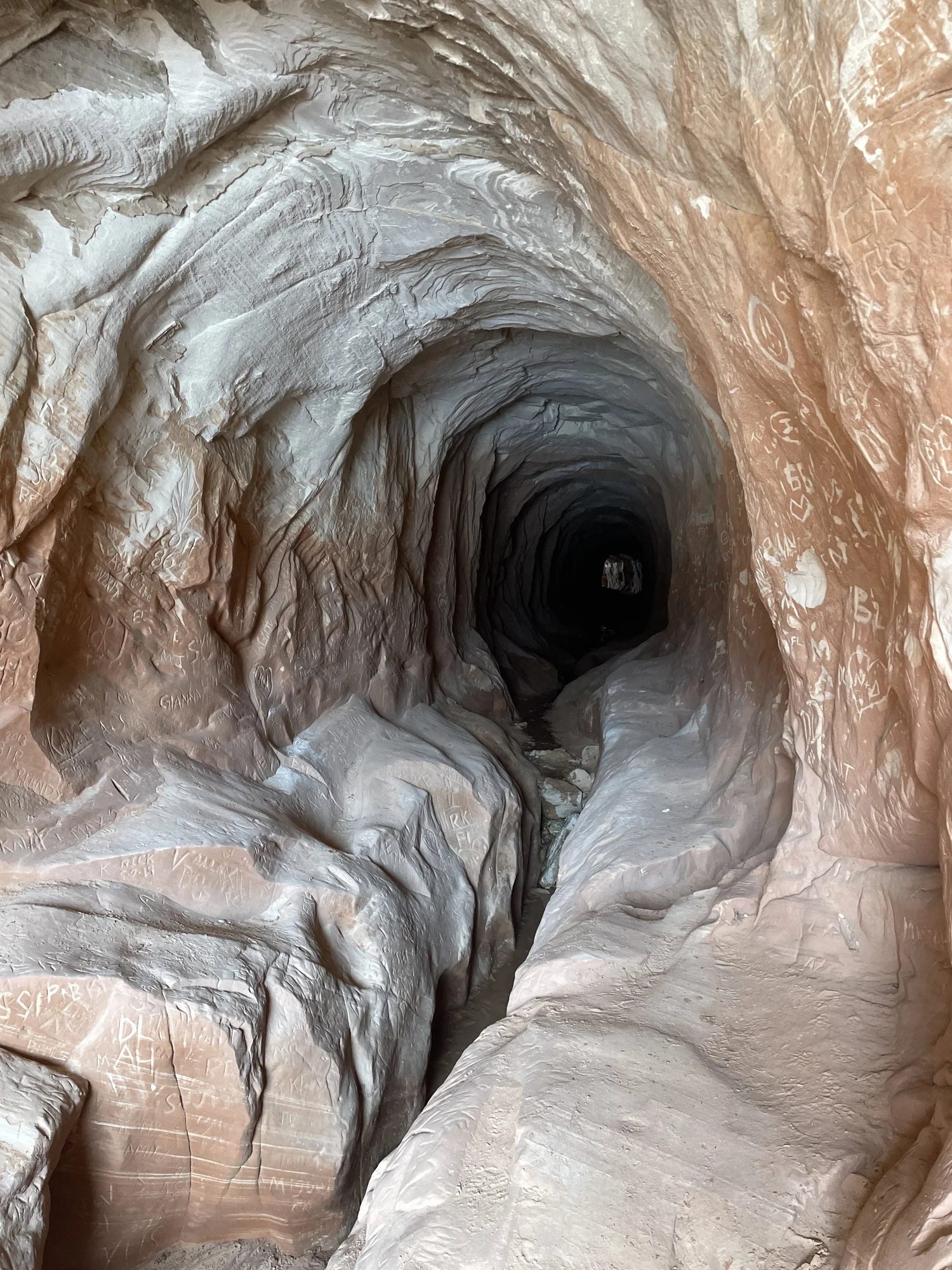
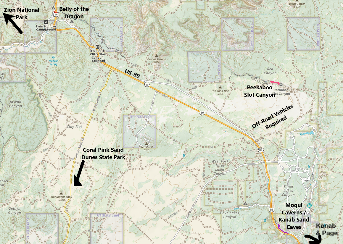
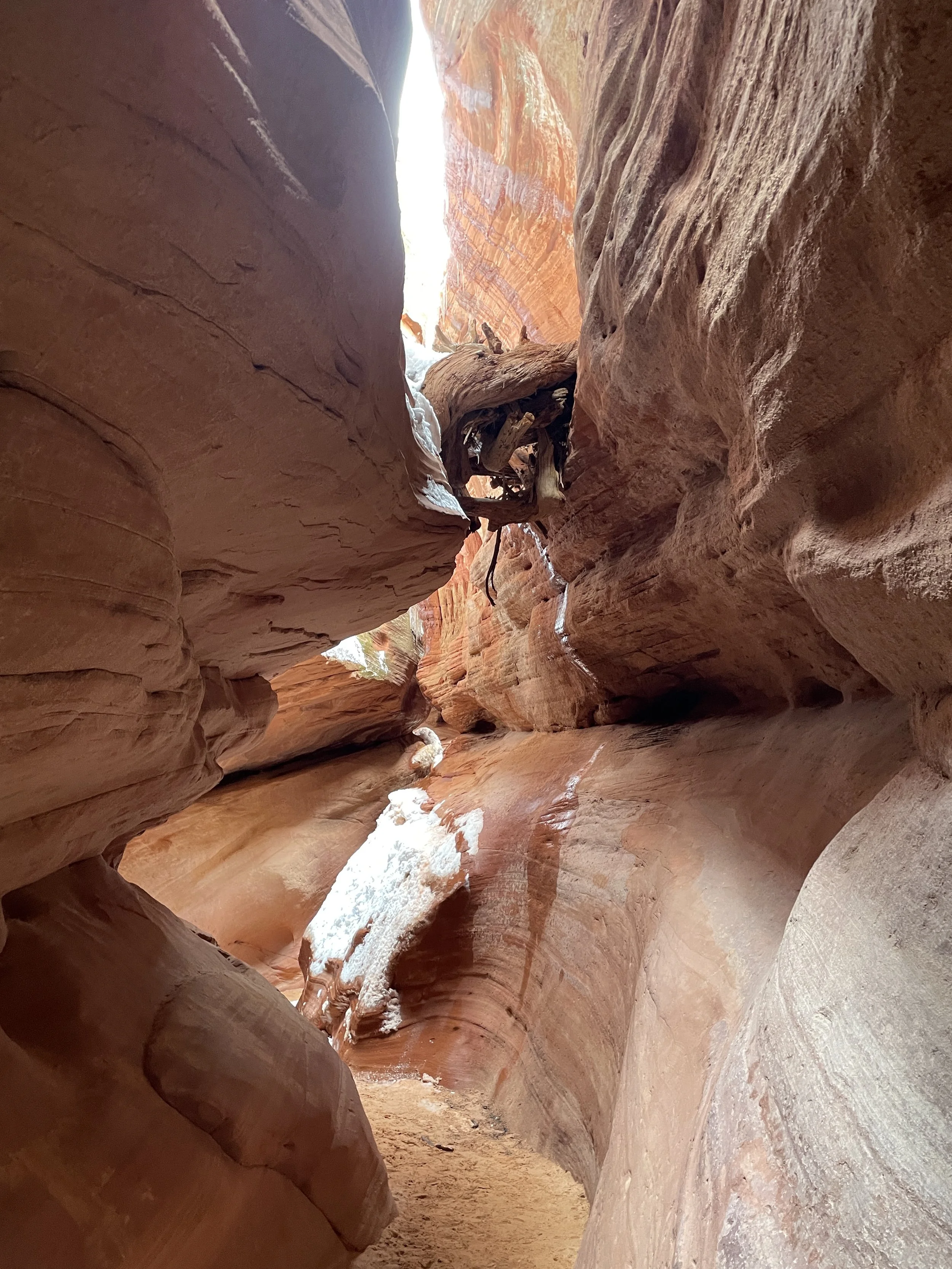
12 - Belly of the Dragon
Belly of the Dragon
Belly of the Dragon is a cool place to stop for hikers of all ages, and it’s just a quick stop off of US-89.
What is Belly of the Dragon?
From internet pictures and posts, I was looking for a cave off in the hills. Let’s expectation set instead. Belly of the Dragon is a water culvert under US-89. It’s a pretty awesome water culvert - there’s a little slot canyon that seems to be starting to form at the base, and it’s cool to see how it begins. But this is a manmade tunnel for water. It’s not a cave, and it’s not natural.
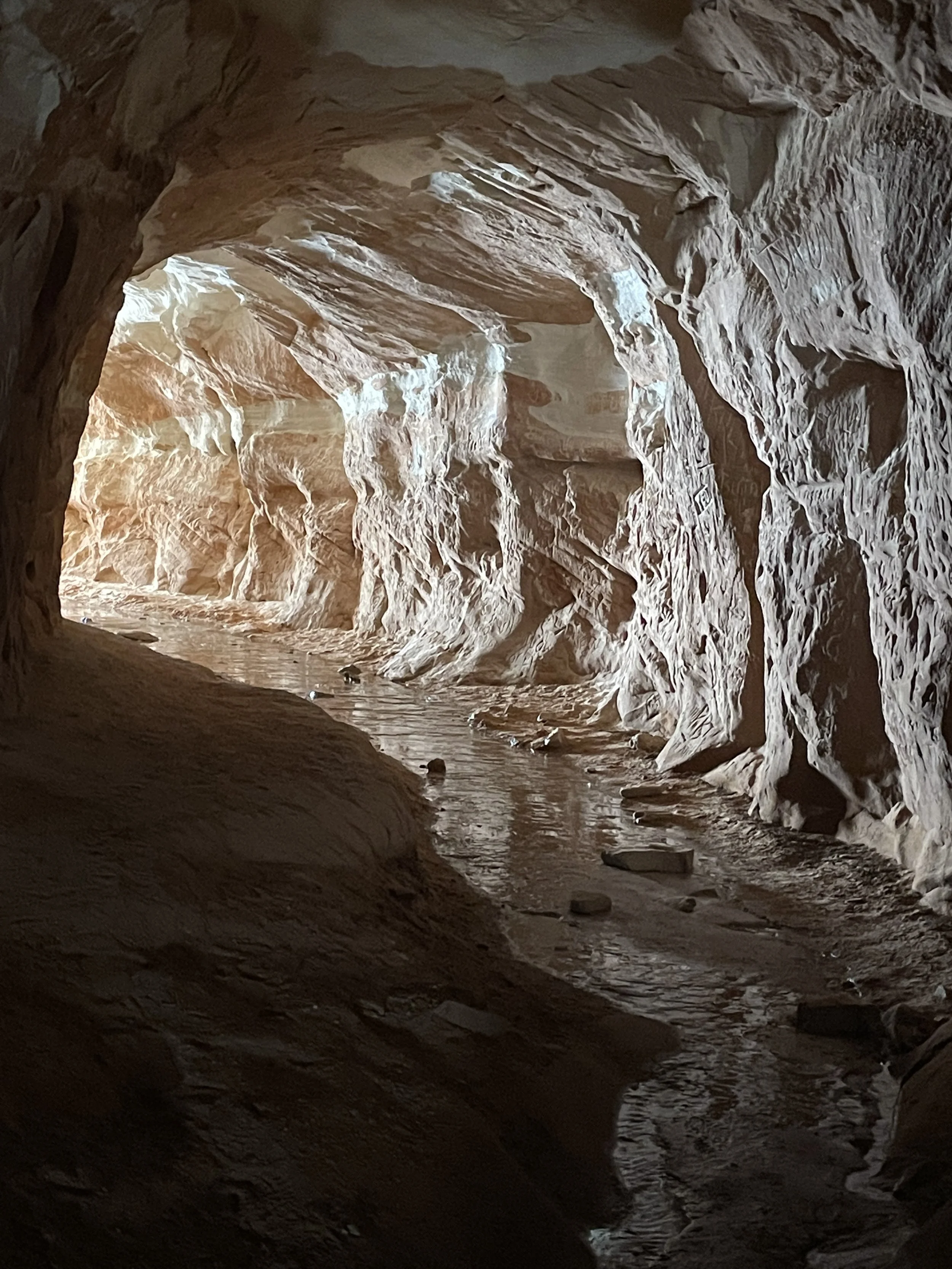
Belly of the Dragon
Where is Belly of the Dragon?
Belly of the Dragon is located under US-89. Exit onto Elephant Gap towards the Twin Hollows Campground. The parking lot will be on your left, about 0.3 miles down the road. Belly of the Dragon is 20 minutes north of Kanab, 20 minutes east of Zion National Park’s east entrance, and 90 minutes from Page. Same as my comments on the Moqui Caverns (Kanab Sand Caves) - this may be fun to combine with a day at Zion. I would pick Belly of the Dragon over the Sand Caves. It’s easy for anyone to see and an even shorter stop.
For anyone interested in hiking more than one day in Zion, consider getting a hotel instead in Kanab, and do a day trip out to Page. Or consider switching hotels.
Location of Belly of the Dragon
More Information on Belly of the Dragon
Belly of the Dragon
For more information, including a trail map and pictures, here is my post on Belly of the Dragon.
13 - Kanab’s Peekaboo Canyon
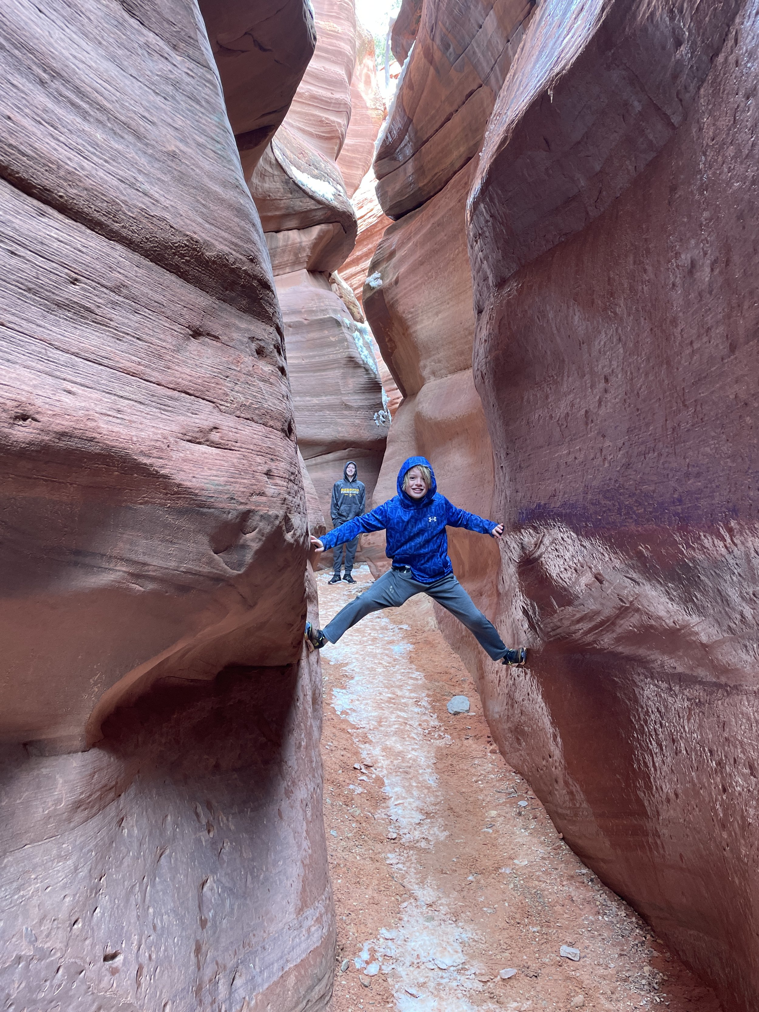
Kanab’s Peekaboo Canyon
Peekaboo is a short and beautiful slot canyon near Kanab (not to be confused with the Peekaboo Slot Canyon in Escalante). This canyon requires an off-road vehicle to get to the trailhead.
Where is Kanab’s Peekaboo Canyon?
The off-road pullout from US-89 to Peekaboo Slot Canyon is a 15-minute drive southeast of Kanab’s Sand Caves. This is an a 90-minute drive from Page (plus the 4x4 road). Repeating content from the Moqui Caverns (Kanab Sand Caves) and Belly of the Dragon, it might be better to get a hotel in Kanab and do a day trip out to Page, or consider switching hotels.
Location of Kanab’s Peekaboo Canyon
Hiking at Kanab’s Peekaboo Canyon
Peekaboo Canyon (in Kanab) is an easy 1 mile out and back hike. The challenge is obtaining a 4x4 vehicle to get out to the trailhead. We were on a canyoneering trip with All Ways Adventures and we had a little bit of extra time, so I asked if we could check out this canyon. I could not recommend this tour group enough! I think there are 4x4 vehicles that can also be rented out from Kanab, Utah.
Kanab’s Peekaboo Canyon
More Information on Kanab’s Peekaboo Canyon
For more information on the canyon, a trail map, and additional pictures, see my post on Kanab’s Peekaboo Canyon.
14 - Reflection Canyon
Reflection Canyon is still on my wish list, but I mention it here for a couple of reasons. First, there are boat tours from Lake Powell that go to Reflection Canyon (taking off from Bullfrog Marina). This does require a short but difficult hike up the canyon wall to see the top-down view. The second reason I mention is to connect how close things actually are, even if it takes a longer drive to physically get between places. The hiking trailhead to Reflection Canyon is down Hole-in-the-Rock Trail Road. This is over a 5-hour drive from Page. The closest city is actually Escalante, and this trailhead road is the same road that is used to access Zebra Canyon, and Peekaboo and Spooky Gulch slot canyons (same name as the Kanab Peekaboo Canyon, but very different canyon - much harder, as well as physically located near a different city).
Where is Reflection Canyon?
Both the trailhead and the Bullfrog Marina are much closer to Escalante, Utah than Page. But it’s a place that could be combined on the same road trip.
The out-and-back hike is over 20 miles (which is why I haven’t yet tackled this trail…) Some day when my boys are either old enough to help me carry enough water, or when they have moved out and it’s just my husband left with me who promised to take care of me in sickness and health… Or preventing me from dying on a hike?? He’s held pretty strong on this promise so far. We’ve had some great adventures.
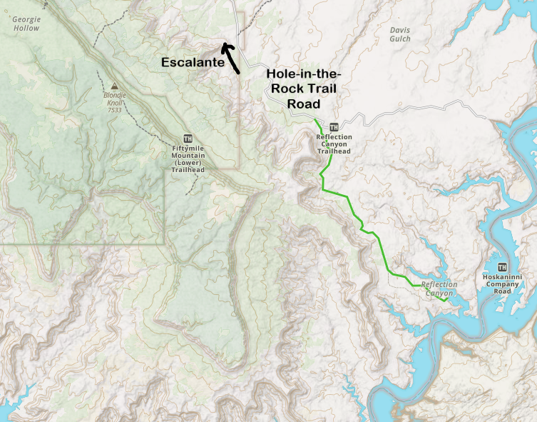
Map of Reflection Canyon
More Information on Other Hikes in Escalante, Utah

Escalante - Devil’s Garden (accessed from the Hole-in-the-Rock Trail Road)
For other hikes and nearby things to do, here is my post on Escalante, Utah.
15 - Zion National Park
Zion is one of my favorite National Parks - probably my second favorite, after Arches. It is such a beautiful place and there are so many things to do for all different types of hiking abilities.

Zion National Park - The Narrows
Where is Zion National Park?
Zion National Park is located in the southeastern part of Utah. The eastern entrance is closest to Page, and is about 2 hours and 15 minutes away. Zion is west of Page, along US-89. My best recommendation is to switch hotels and spend a few nights in either Kanab, Springdale, or St. George, Utah to best explore Zion. Page can be a day trip from any of these places, or it can be a separate destination.
More Information for Visiting Zion National Park

Zion National Park - Kolob Canyon
For my complete review of Zion National Park, including information on 23 hikes (pictures, trail maps, and additional logistical information), see my post on Zion.
16 - Monument Valley Tribal Park

Monument Valley Tribal Park
Monument Valley is located in this relatively flat section of desert… and all of a sudden there are huge, dramatic rock sculptures that stretch upwards with incredible height and imaginative shapes. It’s also the site of where Forrest Gump stops running (US-163 mile marker 13) - for anyone interested in its pop culture reference.
Where is Monument Valley Tribal Park
Monument Valley is about 2 hours east of Page, on the border of Arizona and Utah. Follow AZ-98E and then US-160 to US-163. Monument Valley could be a fantastic day trip destination from Page. Or, if you are considering adding Arches National Park and/or Canyonlands National Park to your road trip, then Monument Valley might be a great place to spend the night. Monument Valley is about the midway point between Page and Moab, Utah (Moab is the city closest to both Arches and Canyonlands).

Monument Valley Tribal Park
More Information for Visiting Monument Valley Tribal Park
For more information, including hiking trails, the driving route, and where to spend the night, see my post on Monument Valley Tribal Park.
17 - Grand Canyon National Park

Grand Canyon National Park - South Rim
It’s hard for me to explain just how much the Grand Canyon has shaped my outdoor life. I’ve been down to the bottom of this canyon 4 times so far (yes - it takes months of planning and training to hike this canyon). It’s the hardest hike I’ve ever done (each time) and yet it’s a place that my soul finds rest. There are amazing viewpoints from the top (for those that just want to gaze into it), out-and-back hikes from the rim (for those that want to step a bit into it), and bridges that cross over the Colorado River (for those looking for incredibly difficult rim-to-rim hikes).
Where is Grand Canyon National Park
The South Rim is two and a half hours from Page, starting south along US-89. And we won’t talk about the North Rim… I’m still heartbroken from the loss of the lodge during the fire that occurred in the summer of 2025.
This could be a day trip from Page, for those that just want to see the Grand Canyon from the viewpoints - and that’s impressive on its own. For anyone serious about hiking, you will want to switch hotels so you can start your hike early in the morning (and when I say early…. sometimes that means 3-4am depending on how far you want to go, as that sun will bake you in the canyon, especially at the bottom).

Grand Canyon - North Kaibab Trail
More Information on Grand Canyon National Park
I haven’t yet written a useful visitor guide on the Grand Canyon. All I have so far is the story of our first rim-to-rim-to-rim hike. It’s not helpful, but for anyone interested in reading stories of those that explore spaces outside, it’s worth a quick read, or at least look at the pictures.

Grand Canyon South Kaibab Trail - Sunrise at Ooh Aah Point
More from www.NatureImpactsUs.com
To see more of my posts, click on any pin. There will be a hyperlink to my post on that particular hike.